
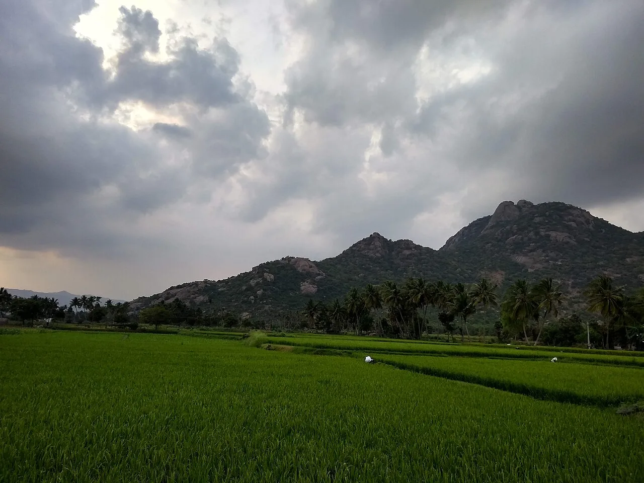
Kalrayan Hills
Kalrayan Hills are an extensive highland range in Tamil Nadu’s Eastern Ghats. Visitors come to experience its elevated terrain and its setting among the ranges that separate two river basins.
Key facts · verified by Ghumoopedia editors
- Type of place
- Temple / pilgrimage site
- Best time to visit
- November to February; April to June for the hill stations
- Nearest railway station
- Salem Junction · about 58 km (straight line)
- Nearest airport
- Salem Airport · about 62 km (straight line)
- Verified
- 21 Nov 2026
Plan a trip from Kalrayan Hills — a day-by-day route through places nearby.
The Kalrayan Hills lie in Kallakurichi district, Tamil Nadu, and form part of the Eastern Ghats in the south of India. The range is also known as the Kalvarayan Hills. Alongside the Pachaimalai, Alavaimalai, Javadi and Shevaroy hills, it marks the division between the Kaveri River basin to the south and the Palar River basin to the north. Elevations across the hills run from 2,000 to 3,000 feet, and the range covers 1,095 square kilometres. Its broad area and upland character are features visitors can experience while exploring this part of Tamil Nadu. Tamil Nadu is the land of great living temples — Madurai's Meenakshi, Thanjavur's Brihadeeswara, Srirangam, Chidambaram and Rameswaram — along with the Pallava shore monuments of Mamallapuram, the Chettinad mansions, the hill stations of Ooty and Kodaikanal and the meeting of three seas at Kanyakumari. The state is hot from March to June, gets light southwest-monsoon rain from June to September, and receives its main rainfall from the northeast monsoon between October and December. January to March is the most comfortable season; the Nilgiri and Kodaikanal hills are cool year-round. The usual best time to visit is November to February; April to June for the hill stations. Timings, fees and access arrangements must be confirmed locally. For official information, see Tamil Nadu Tourism at https://www.tamilnadutourism.tn.gov.in.
Why it matters
Kalvarayan Hills, also written Kalrayan Hills, are a significant Eastern Ghats range in Kallakurichi district, Tamil Nadu. The range is described in the existing guide as separating the Kaveri River basin to the south from the Palar River basin to the north, together with other hill ranges. Its reported elevations are about 2,000–3,000 feet, and it covers roughly 1,095 square kilometres. The hills matter regionally for their landscape, local livelihoods and access to upland villages, as well as for nature-based visits. They are a geographical region, not one single temple or pilgrimage complex. No UNESCO or Archaeological Survey of India designation for the hills as a whole is established here; check official sources for the status of any specific site.
Kalvarayan Hills are a broad hill region rather than a single monument, so they do not have one known builder, foundation date or restoration history. Their established context is geographical: the range forms part of the Eastern Ghats in present-day Kallakurichi district and, with neighbouring ranges, divides major river basins. The name also appears in the forms Kalrayan and Kalvarayan. The uplands have long been home to villages and communities whose work and movement are shaped by the hills, forests and access routes. Specific accounts of settlement history, land tenure and community traditions may differ from village to village and should be sought from local sources rather than assigned to the entire range. The available guide does not document a particular dynasty, temple-building phase, inscriptional record or major conservation project for the hills as a whole. Roads, visitor access and administrative boundaries have changed over time, but details should be verified with district or forest authorities. Visitors interested in the history of a particular shrine, village or archaeological feature should ask locally and treat unverified dates or origin stories as local tradition, not established chronology.
Origin stories & folklore
No single, widely documented origin legend for the Kalvarayan Hills is established in the available guide. As in many hill regions, individual villages and shrines may preserve their own stories about guardian deities, sacred groves, springs or unusual rock formations. These accounts belong to local belief and oral tradition; they should not be presented as one story shared by every community across the range. Visitors who hear a story can ask whether it is connected to a particular village or place and whether it is appropriate to record or photograph the site. Respect local explanations without assuming that a natural feature is a formally recognised pilgrimage landmark.
Architecture & design
The Kalvarayan Hills are a natural landscape, not a single architectural complex with a unified plan or building style. Their character is defined by upland slopes, ridges, valleys and settlements spread across a large area. Buildings and places of worship, where present in individual villages, reflect local needs and materials rather than a documented design scheme for the whole range. Do not assume that every viewpoint or waterfall is part of a constructed visitor site. Routes may include village roads, paths and uneven ground; their condition can vary with weather and maintenance. The existing guide recommends using marked paths and official viewpoints, and checking locally whether a guide, entry ticket or forest permission is required. There is no established claim here about a signature temple, engineered terrace system or particular construction material. Ask locally before entering buildings or sacred areas, as access customs can differ between communities and sites.
Important objects & sculptures
There is no single documented collection of sculptures, idols or inscriptions associated with the Kalvarayan Hills as a whole. Any sacred objects or carved features belong to particular village shrines or other local places and should be identified in their own context. The general guide does not establish a museum, archaeological collection or named inscription for visitors to seek out across the range. If visiting a shrine, ask a local custodian what can be viewed and whether photography is appropriate; some objects may be used in worship and not displayed as tourist attractions. Natural features such as rock faces and streams are part of the landscape, but should not be described as carved or historically significant without reliable local or official evidence.
Religious significance
Kalvarayan Hills are identified primarily as a hill range, not as one central temple or pilgrimage destination with a single presiding deity. Worship in the area may be connected to individual village temples, local deities or sacred places, but the available guide does not specify a principal shrine, established ritual schedule or shared religious tradition for the entire range. Visitors planning a devotional visit should identify the particular shrine in advance and ask residents or its custodians about customary conduct, offerings and access. Treat active places of worship respectfully: follow local directions, dress modestly and avoid interrupting prayer. Do not assume that scenic viewpoints, forest areas or waterfalls are religious sites unless local people identify them as such.
Spend unhurried time at Kalrayan Hills: walk the marked paths, use official viewpoints and ask locally whether a guide, entry ticket or forest permission is needed. Weather can change quickly in the hills, so carry a rain layer even on a clear morning. A comfortable itinerary is one main visit in the morning, a local meal at midday and a short nearby stop before an afternoon return. Use the district list on this site to find other places in Kallakurichi, but check the route and its condition before combining stops. If a festival is on — such as Pongal in January, the Madurai Chithirai festival, the Mahamaham at Kumbakonam or the Chennai music season in December — roads and stays can be busy, and the experience can be unforgettable. Leave no litter: many sites are protected by the communities around them.
Suggested itineraries
Half day: Check local access and road conditions (30 minutes); visit one authorised viewpoint or short path (1–2 hours); have a local meal and return (1–2 hours). Full day: Begin with a locally confirmed viewpoint or walk (2–3 hours); pause for lunch in a village or town (about 1 hour); visit one nearby, accessible stop if roads and permissions allow (1–2 hours); return before conditions change. Gentler option: Choose one road-accessible viewpoint, keep walking short, and plan a relaxed meal and return with a private vehicle.
Life in the Kalvarayan Hills is associated with upland villages and the wider cultures of Kallakurichi district. Languages, customs and devotional practices can vary between communities and settlements; Tamil is widely used in the district, but visitors should not assume every local tradition is identical. The available guide does not document a particular dance, music form or dress code unique to the whole range. Local food, village markets and community events offer a more grounded way to learn about daily life than treating the hills as a staged cultural attraction. Ask permission before photographing residents, homes or ceremonies, and follow community guidance around sacred places and forest areas.
Festivals & events
There is no single hill-wide festival calendar established in the available guide. Individual villages may celebrate temple festivals or community events at different times of year; ask locally for current details before planning around one. Pongal, generally celebrated in January, is an important Tamil harvest festival, though its observance and visitor activities vary by place. Festival periods can bring more people and traffic to village centres or nearby towns, and accommodation or transport may be busier. Do not assume that major festivals elsewhere in Tamil Nadu, such as Madurai's Chithirai festival, are held in the Kalvarayan Hills.
Local food in Tamil Nadu includes idli, dosa and filter coffee, Chettinad chicken and pepper curries, Madurai's kari dosa and jigarthanda, Thanjavur's banana-leaf vegetarian meals, Kanyakumari's seafood, and sweets such as Mysore pak, adhirasam and Tirunelveli halwa. Ask what is fresh that day; many small eateries cook a limited daily menu. Tamil Nadu is a paradise for vegetarian meals served on banana leaf; Chettinad and Madurai are the centres for meat and spice lovers. Filter coffee is a ritual — have it at a local 'hotel' (eatery). Remote sites may have no restaurant at all. Carry water and snacks, eat a proper breakfast before long drives, and ask your accommodation for a packed lunch if you are heading out early. Try a home-cooked or local thali meal when you can — it is often the best food on the route. Choose busy, clean places, drink sealed or filtered water, and carry your packaging back with you.
Shopping & local experiences
Treat shopping as a village- and town-based experience rather than expecting a dedicated souvenir market in the hills. Look for locally made or grown goods in markets around Kallakurichi and nearby settlements, and ask sellers about the source of any forest or farm products. Do not buy wildlife products, plants or items whose collection may be restricted. Local meals and seasonal produce can be a good way to support nearby businesses. Carry reusable bags and avoid leaving packaging behind.
November to February; April to June for the hill stations
The nearest principal railway station by straight-line distance is Salem Junction, roughly 58 km away. The nearest operating airport by straight-line distance is Salem Airport, roughly 62 km away. These figures are calculated from map coordinates — actual road distance is longer. Chennai is the main gateway; Coimbatore serves the west and Mettupalayam is the railhead for the Ooty toy train; Madurai and Tiruchirappalli serve the south and centre; Rameswaram and Kanniyakumari have their own rail termini. For the final leg, TNSTC and SETC buses reach nearly every town, with private sleeper coaches between cities and app cabs in Chennai, Coimbatore and Madurai link district towns. A private taxi gives more flexibility for remote sites such as hill stations, forest gates and coastal temples. When comparing train, bus and flight, count the complete door-to-door time: a flight saves the most time only if the onward road transfer is short, while an overnight train can save a hotel night. Book your return before you leave, because seats fill quickly on weekends, festivals and holidays. Current train numbers, timings, return services and fares are not listed here; check IRCTC and NTES for trains and the airline's own schedule for flights. No permit is needed to visit Tamil Nadu. The Nilgiri Mountain Railway toy train to Ooty must be booked well in advance on IRCTC — seats are few and sell out weeks ahead. Major temples such as Madurai Meenakshi and Srirangam have darshan queues and some enforce a dress code (dhoti or formal trousers for men, saree or salwar for women); phones and cameras are not allowed inside several temple sanctums. Boating to the Vivekananda Rock at Kanyakumari depends on sea conditions.
Confirm onward and return timings on IRCTC / NTES, the state bus operator or your airline before travel. A dash means current timings or fares have not been verified.
Getting around
Plan local movement before arriving, as the hills cover a wide area and services may be limited away from towns and villages. A private taxi or locally arranged vehicle is generally more flexible for reaching viewpoints or remote stops; ask the driver about road conditions and authorised access. Local buses may serve some settlements, but routes and frequency should be checked locally. Autos may be available around busier village centres, though not necessarily for the full hill route. Walk only on appropriate paths and avoid setting out on unfamiliar trails without local advice. Confirm parking availability at each stop rather than assuming there is a formal car park.
Hours, tickets & permissions
The hills are a large region rather than a single gated attraction, so access arrangements may differ by route, viewpoint, forest area or shrine. Tickets, permits, camera restrictions, identity requirements and any dress guidance depend on the specific place visited. Forest access may be regulated, and visitors should use authorised routes rather than entering restricted areas. Confirm current access rules, hours and any fees with the relevant local or forest authority before travelling; do not rely on informal online listings for site-specific conditions.
Facilities
Facilities vary across this extensive hill region. Toilets, drinking water, food stalls, parking and cash access may be available in some villages or busier visitor areas, but should not be expected at every viewpoint or along every route. Carry water and essential supplies from a larger town, and check locally before relying on food or toilet facilities. Guides may be available for particular routes, but availability and any required permissions need confirmation. Mobile connectivity and ATMs can be limited away from established towns; plan accordingly.
Accessibility
The terrain is hilly, and paths or access roads may be uneven, steep or affected by rain. Walking distances and surfaces vary by stop; there is no single accessibility standard for the whole range. Shade, seating and handrails should not be assumed. Wheelchair and stroller access may be difficult beyond a vehicle-accessible viewpoint, while older visitors or anyone with limited mobility should choose a short, locally checked route and allow time to rest. Ask about the surface and vehicle access at the specific destination before setting out. Avoid attempting a trail if weather, footing or health makes it unsafe.
No permit is needed to visit Tamil Nadu. The Nilgiri Mountain Railway toy train to Ooty must be booked well in advance on IRCTC — seats are few and sell out weeks ahead. Major temples such as Madurai Meenakshi and Srirangam have darshan queues and some enforce a dress code (dhoti or formal trousers for men, saree or salwar for women); phones and cameras are not allowed inside several temple sanctums. Boating to the Vivekananda Rock at Kanyakumari depends on sea conditions. Carry a photo ID at all times and save the emergency number 112 and your accommodation's contact offline. Ghat roads have hairpin bends and mist; avoid night driving in the hills, keep to marked trails and stay back from cliff edges in rain. Stay on marked paths, keep away from cliff edges and fast water, and never approach wild animals.
Visitor rules
Follow signs and directions from local or forest authorities, and use permitted routes only. Check whether forest permission or a guide is required before entering a trail or restricted area. Wear practical footwear and modest clothing, especially when visiting a village shrine. Carry litter out, avoid single-use plastic where possible, and do not damage plants, rocks or local property. Keep noise low near homes, wildlife and places of worship. Ask before photographing people, ceremonies or shrine interiors, and respect any local restrictions or requests to leave a place undisturbed.
Photography
Morning or late-afternoon light can suit landscape photography, but cloud, rain and visibility change quickly in the hills. Use only authorised viewpoints and paths, and check local rules before photographing near forest areas or shrines. Photography of residents, worshippers and ceremonies should be by permission, not assumption. Avoid intrusive flash inside active places of worship. Drone use may be restricted by aviation rules, forest controls or local permissions; confirm before flying and do not launch near people, wildlife or sacred places.
Choose a stay by the full journey to Kalrayan Hills, not just the district name. Chennai, Coimbatore, Madurai and Tiruchirappalli offer the widest choice; Ooty and Kodaikanal have everything from heritage hotels to cottages — book far ahead for the April–June school holidays and the Pongal weekend. In the hills, nights are cold from November to February — check heating and hot water. Book in advance for weekends, festivals and the peak season (November to February; April to June for the hill stations). Confirm the exact location, meals included, check-in time and cancellation terms in writing. Avoid sending money to unverified contacts or touts at stations. Carry some cash, as card and digital payments can be unreliable in remote areas.
Kallakurichi town is a practical nearby centre for services and onward travel. Gomukhi Dam is a named local attraction in the wider Kallakurichi area and may be considered as a separate stop, subject to current access and route conditions. Chinnasalem is another nearby town useful for planning local movement. The district also has village shrines and rural places of interest, but visitors should confirm their location and public access locally rather than assume they are established tourist sites. Check road conditions before combining any stops with a hill visit.
For couples, Kalrayan Hills rewards a slow pace: arrive early for soft light and fewer crowds, share a local meal and keep the evening free. Sunrise at Kanyakumari, a boat ride on Kodaikanal lake or an evening stroll through Mamallapuram's shore monuments makes the trip memorable. Public displays of affection can be frowned upon in conservative communities and at religious sites, so be discreet. Keep a buffer in your itinerary, because weather and road conditions can delay plans.
Q: How much time should I allow for a visit? A: A half day can suit one locally confirmed viewpoint or short walk; a full day allows for a relaxed visit and one additional stop if roads and access permit. Q: When is a good season to visit? A: November to February is generally the more comfortable period in the guide. Rain and changing conditions are possible, so check the forecast and local advice. Q: Is there an entry ticket or permit? A: The hills are a large region, not one ticketed site. Rules vary by stop; confirm any ticket or forest permission with the relevant authority. Q: Are the hills suitable for children and older visitors? A: They can be, if you choose an accessible stop and keep walks within everyone's ability. Paths may be uneven, and facilities vary. Q: Where can I stay nearby? A: Look for accommodation in Kallakurichi or another suitable town and confirm availability before travel. Options within the hill villages may be limited.
Be the first to share photos, stories, advice or a helpful contact for Kalrayan Hills.
Loading…