
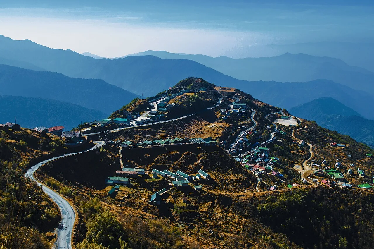
Dzuluk
Dzuluk, also known as Zuluk, Jhuluk or Jaluk, is a hamlet in Sikkim’s Pakyong district. Visitors go there for views of the eastern Himalayas, including Kanchenjunga.
Key facts · verified by Ghumoopedia editors
- Type of place
- Natural attraction
- Best time to visit
- March to May and October to December; avoid the June–September monsoon
- Nearest railway station
- Siliguri Junction · about 69 km (straight line)
- Nearest airport
- Pakyong Airport (limited, weather-dependent flights) · about 19 km (straight line)
- Verified
- 21 Nov 2026
Plan a trip from Dzuluk — a day-by-day route through places nearby.
The settlement is a small hamlet in Sikkim, set at about 9,400 feet (2,900 metres) among the rugged lower Himalayan landscape. Dzuluk is another spelling used for the place, alongside Zuluk, Jhuluk and Jaluk. It falls within Rongli Subdivision of Pakyong District, and its postal code is 737131. Dzuluk is an emerging, offbeat destination for travellers in Sikkim. Visitors come for views towards the eastern Himalayan range, including Kanchenjunga. These mountain vistas are the main reason the hamlet has become a tourist destination. Sikkim is a small Himalayan state wrapped around Kangchenjunga, the world's third-highest peak, with Buddhist monasteries such as Rumtek, Pemayangtse and Tashiding, Lepcha, Bhutia and Nepali communities, high-altitude lakes like Tsomgo and Gurudongmar, rhododendron valleys at Yumthang and Varsey, and a strong commitment to organic farming and clean, plastic-light tourism. Weather depends on altitude: Gangtok and Pelling are mild in spring and autumn and cold in winter, while North Sikkim and Nathu La lie under snow from December to March. The monsoon (June to September) brings heavy rain and frequent landslides. Spring is rhododendron season; October and November give the clearest views of Kangchenjunga. The usual best time to visit is March to May and October to December; avoid the June–September monsoon. Timings, fees and access arrangements must be confirmed locally. For official information, see Sikkim Tourism at https://www.sikkimtourism.gov.in.
Why it matters
Dzuluk, also written Zuluk, Jhuluk or Jaluk, is a small hamlet in Rongli subdivision of Pakyong district, Sikkim, at about 2,900 metres (9,400 feet). Its regional significance comes from its position on the historic route towards Jelep La and from its views across the eastern Himalaya, including, in clear conditions, Kangchenjunga. The settlement is also a starting point for exploring nearby mountain roads and viewpoints. Tourism here is relatively recent compared with better-known Sikkim destinations, and local stays and services remain modest.
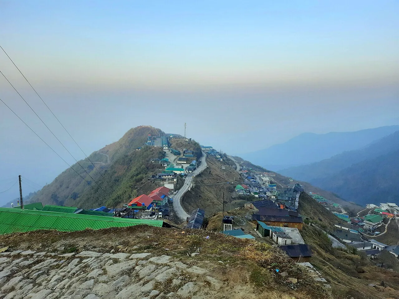
Dzuluk is associated with the old trade route that crossed the eastern Himalaya towards Tibet through Jelep La. The wider route connected trading places in the Bengal hills and Sikkim with markets beyond the Himalayan passes. Traders and travellers used this difficult terrain, and settlements along the route provided places to pause on journeys through the mountains. The history belongs to a network of paths and passes rather than to a single surviving monument or documented founding event, so a precise founding date for the hamlet is not established here. Cross-border trade and travel changed substantially after the India-China border closed in 1962. Dzuluk’s role as a transit settlement diminished, while the region retained strategic importance because of its proximity to the international border. Roads and associated infrastructure later made access easier for some visitors, though travel remains subject to local conditions and permit rules. In more recent years, Dzuluk has emerged as a small tourism destination, with visitors drawn by mountain scenery and the route’s history. This change has brought income through homestays and local services, but tourism facilities remain limited. There is no widely documented major restoration project or historic building complex at the hamlet.
Origin stories & folklore
No single, well-documented origin legend for Dzuluk is established in reliable general sources. Stories about the old trade route are best treated as local memories and oral histories rather than as verified accounts of the hamlet’s founding. Across Sikkim, mountains, passes and lakes may carry religious or cultural meanings for local communities, but beliefs differ and some knowledge is private or specific to a community. Visitors can ask hosts whether they are comfortable sharing local stories, without pressing for sacred or restricted information. The name is also written in several forms, including Zuluk, Jhuluk and Jaluk; these spellings reflect usage and transliteration, not necessarily separate legendary origins.
Use Dzuluk as a base to understand local life: walk through the market, look for local crafts such as Lepcha weaving, Tibetan carpets, thangka paintings, Temi tea and organic cardamom and ask your host about nearby viewpoints and short excursions. Always ask before photographing people, homes or ceremonies. A comfortable itinerary is one main visit in the morning, a local meal at midday and a short nearby stop before an afternoon return. In the mountains, mornings are clearest; clouds often roll in by noon, so start early for views of Kangchenjunga. Use the district list on this site to find other places in Pakyong, but check the route and its condition before combining stops. If a festival is on — such as Losar (Tibetan New Year), Saga Dawa, Pang Lhabsol, Losoong, Bumchu at Tashiding, Dasain and Tihar or the Gangtok winter carnival — roads and stays can be busy, and the experience can be unforgettable. Leave no litter: Sikkim restricts plastic and packaged water in many tourist areas, so carry a refillable bottle.
Suggested itineraries
Half day: Spend about 1–2 hours walking around the hamlet, have a local meal, then allow 1–2 hours for a nearby viewpoint or short drive, subject to road and weather conditions. Full day: Start early for a nearby viewpoint, allow 2–3 hours for the drive and stops, return for a meal, then spend 1–2 hours exploring the settlement or a short local walk. Gentler option: Enjoy views from near your accommodation, take a brief level-as-possible walk with frequent rests, and avoid combining several high-altitude stops.
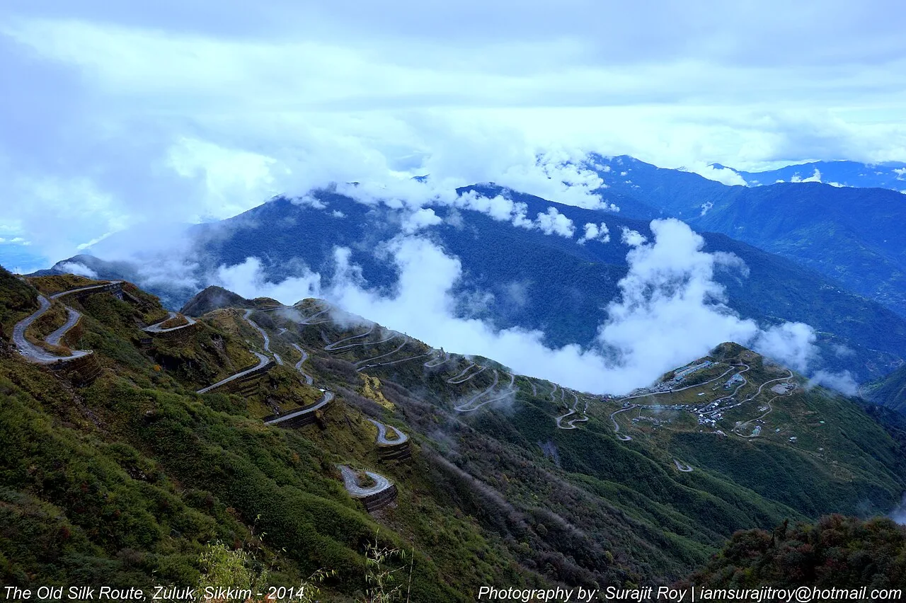
Daily life in Dzuluk reflects a small mountain settlement where hospitality, family-run stays and practical knowledge of local weather and roads are important. Nepali is widely used in the region; other languages may be spoken in households and across Sikkim’s diverse communities. Buddhist traditions are part of the wider cultural landscape, alongside Hindu customs, though practices vary between families. Visitors may encounter regional food and seasonal community observances rather than staged cultural performances. Dress is generally practical for a cold, changeable climate. Ask before photographing people, homes, religious objects or ceremonies, and follow a host’s guidance about customary behaviour.
Local communities
Dzuluk and the surrounding area are home to residents with varied family histories and cultural backgrounds. Nepali-speaking communities are prominent in much of this part of Sikkim; Lepcha and Bhutia communities are also part of the state’s wider social and cultural fabric. Livelihoods in the hamlet and nearby settlements can include homestays, transport, small-scale trade, farming and work connected with roads or other services. Conditions at this altitude shape everyday routines, including food production and travel. Do not assume that a particular craft or tradition belongs to every household; ask residents respectfully and support locally run businesses where possible.
Festivals & events
The wider region observes festivals from Nepali, Bhutia and Lepcha traditions, as well as Buddhist and Hindu calendars. Losar, the Tibetan New Year, usually falls in winter or early spring; Losoong is commonly observed around December, while Dasain and Tihar generally fall in autumn. Dates vary by calendar and community, and these are not necessarily public events held specifically in Dzuluk. Local observances may be small or family-centred. If travelling during a festival period, check accommodation and road conditions in advance: visitors may increase demand, and some services can operate differently. Attend only when welcome and ask before photographing ceremonies.
Local food in Sikkim includes momos, thukpa and thenthuk noodle soups, phagshapa (pork with radish), gundruk and sinki fermented greens, sel roti, churpi (yak cheese), chhurpi soup, local tea from Temi and warm tongba millet brew in the hills. Ask what is fresh that day; many small eateries cook a limited daily menu. Most food is mild compared with the plains, with plenty of vegetarian options; local chilli pastes made from dalle khursani are extremely hot, so try a little first. Hot soups and butter tea help at altitude. Remote sites may have no restaurant at all. Carry water and snacks, eat a proper breakfast before long drives, and ask your accommodation for a packed lunch if you are heading out early. Try a home-cooked or local thali meal when you can — it is often the best food on the route. Choose busy, clean places, drink sealed or filtered water, and carry your packaging back with you.
Shopping & local experiences
Shopping in Dzuluk is limited compared with larger Sikkim towns. Ask locally about small shops, homemade food or goods from nearby producers rather than expecting a dedicated craft market. Sikkim crafts visitors may encounter elsewhere include Lepcha weaving, Tibetan carpets and thangka paintings, but availability in Dzuluk is not assured and these should not be presented as locally made without confirmation. Temi tea and organic cardamom are regional products worth looking for through reliable sellers. Buy directly from local businesses when possible, avoid products made from wildlife, and carry a reusable bottle and bag.
Dzuluk lies on rugged lower-Himalayan terrain, with steep slopes, forested ridges and open views towards the eastern Himalayan range. The surrounding landscape changes with altitude and season: wooded stretches give way to more exposed mountain scenery on higher roads. Rhododendrons and other Himalayan plants may flower in season, but flowering varies with weather and elevation. Small streams and drainage channels occur in the wider area; do not assume they are safe or suitable for drinking. Birds and other wildlife inhabit the surrounding forests, though sightings are never guaranteed. Mornings can offer clearer mountain views, while cloud and rain may reduce visibility. Stay on established routes, avoid disturbing wildlife and take all litter back with you.
March to May and October to December; avoid the June–September monsoon
The nearest principal railway station by straight-line distance is Siliguri Junction, roughly 69 km away. The nearest operating airport by straight-line distance is Pakyong Airport (limited, weather-dependent flights), roughly 19 km away. These figures are calculated from map coordinates — actual road distance is longer, and mountain roads mean even short distances can take hours. Most travellers arrive at Bagdogra Airport or New Jalpaiguri (NJP) railway station near Siliguri in West Bengal, about 4–5 hours' drive from Gangtok; Pakyong Airport near Gangtok has limited, weather-dependent flights. Shared jeeps and reserved taxis run from Siliguri to Gangtok, Namchi, Ravangla and Pelling. From Siliguri or Bagdogra, take a shared jeep, SNT bus or reserved taxi; within Sikkim, shared jeeps leave from the town taxi stands in the morning and fill up early, while reserved taxis give flexibility for monasteries and viewpoints. When comparing train, bus and flight, count the complete door-to-door time: a flight saves the most time only if the onward road transfer is short, while an overnight train can save a hotel night. For Sikkim, flying into Bagdogra saves the most time from distant cities, while a train to NJP is cheaper; either way the road journey up the Teesta valley takes most of a day, so do not plan sightseeing on arrival. Book your return before you leave, because seats fill quickly on weekends, festivals and holidays. Current train numbers, timings, return services and fares are not listed here; check IRCTC and NTES for trains and the airline's own schedule for flights. Indian travellers need no permit for Gangtok, Pelling, Namchi and Ravangla, but a Protected Area Permit — arranged through a registered Sikkim tour operator or taxi association with photo ID and passport photos — is mandatory for Tsomgo Lake, Nathu La, North Sikkim (Lachung, Lachen, Yumthang, Zero Point and Gurudongmar), Zuluk and the Dzongri–Goecha La trek. Foreign nationals need a free Restricted Area Permit, issued online or at the Rangpo and Melli checkposts, and cannot visit Nathu La; some areas allow foreigners only in groups. Nathu La is open on limited days each week and closes after snowfall, and landslides can shut any road at short notice.
Confirm onward and return timings on IRCTC / NTES, the state bus operator or your airline before travel. A dash means current timings or fares have not been verified.
Getting around
Dzuluk is a small settlement, and visitors generally rely on a reserved vehicle or locally arranged taxi for travel between hamlets and viewpoints. Ask your accommodation to help arrange transport and confirm that the driver is permitted to use the intended route. Shared vehicles may be limited, and local buses should not be assumed to serve every stop. Within the hamlet, short journeys may be made on foot, but roads can be steep, narrow and affected by weather. Parking is informal and space may be limited; do not block the road or access for residents. Confirm road conditions before setting out.
Hours, tickets & permissions
Dzuluk is a settlement rather than a conventional ticketed attraction, so there may be no single entrance gate or standard admission arrangement. Travel through the surrounding border region can require permits, and rules may differ by nationality, route and current security conditions. Carry valid identification and confirm requirements before setting out with the relevant Sikkim authorities, your accommodation or an authorised local operator. Do not assume that access to nearby viewpoints or restricted areas is included simply because you have reached the hamlet. Confirm any current opening arrangements, entry rules and fees with the managing authority or local officials.
Facilities
Dzuluk has small-scale visitor services, often centred on homestays and locally run accommodation. Meals may be available through a host or a modest local eating place, but choice and supply can be limited. Toilets and drinking water are usually available at accommodation; check arrangements before booking and use treated or safely supplied water. Do not count on public toilets, fuel, an ATM, a pharmacy or a visitor information centre in the hamlet. Parking and guides may be arranged locally but are not guaranteed. Carry essential medicines, snacks and cash, and confirm facilities and road access with your host.
Accessibility
The hamlet is in steep mountain terrain, with uneven surfaces, sloping roads and changing weather. Reaching viewpoints may involve vehicle travel followed by walking on rough or exposed ground; distances and gradients vary. Shade and sheltered resting places are not assured. The area is generally challenging for wheelchair users and may also be difficult for strollers, people with limited mobility and some older visitors. No continuous step-free route or accessible facilities should be assumed. Visitors with mobility or health concerns should discuss specific needs with their accommodation before travel, allow extra time and avoid walking alone on narrow roads.
Indian travellers need no permit for Gangtok, Pelling, Namchi and Ravangla, but a Protected Area Permit — arranged through a registered Sikkim tour operator or taxi association with photo ID and passport photos — is mandatory for Tsomgo Lake, Nathu La, North Sikkim (Lachung, Lachen, Yumthang, Zero Point and Gurudongmar), Zuluk and the Dzongri–Goecha La trek. Foreign nationals need a free Restricted Area Permit, issued online or at the Rangpo and Melli checkposts, and cannot visit Nathu La; some areas allow foreigners only in groups. Nathu La is open on limited days each week and closes after snowfall, and landslides can shut any road at short notice. Carry a photo ID at all times and save the emergency number 112 and your accommodation's contact offline. Mountain roads are narrow and prone to landslides, especially from June to September; travel in daylight, use experienced local drivers, and keep a spare day in your plan for road closures. Watch your belongings in crowds and on public transport, and follow posted instructions.
Photography
Early morning often gives the best chance of clear mountain views; clouds may build later, and conditions change quickly. Viewpoints and roadside pull-offs offer opportunities for landscape photographs, but visibility is never guaranteed. General photography outdoors is usually possible, subject to local signs and restrictions. Ask permission before photographing residents, homes, children or religious observances, and respect anyone who declines. Do not fly a drone without checking current permissions and local security rules; border-area restrictions may apply. Keep away from road traffic while taking pictures and leave no litter.
Choose a stay by the full journey to Dzuluk, not just the district name. Gangtok has the widest choice, from homestays to boutique hotels along MG Marg; Pelling hotels face Kangchenjunga, and village homestays in Yuksom, Aritar, Okhrey and Dzongu offer a quieter, local experience. In summer, check air-conditioning; in the monsoon, check that the property is accessible if roads flood. Book in advance for weekends, festivals and the peak season (March to May and October to December; avoid the June–September monsoon). Confirm the exact location, meals included, check-in time and cancellation terms in writing. Avoid sending money to unverified contacts or touts at stations. Carry some cash, as card and digital payments can be unreliable in remote areas.
Nearby stops commonly associated with the route include Thambi View Point, Lungthung and Nathang (Gnathang) Valley, each offering a different perspective on the high mountain landscape. Kupup Lake and the area around Jelep La are further route options, but access can be restricted or affected by weather and security conditions. Tsomgo Lake and Nathu La are other well-known eastern Sikkim destinations, though they are not casual add-on stops and require separate route planning and permit checks. Confirm which places are open and reachable before combining them; mountain distances can take much longer by road than a map suggests.
For couples, Dzuluk rewards a slow pace: arrive early for soft light and fewer crowds, share a local meal and keep the evening free. Sunrise over Kangchenjunga from Pelling or Tashi View Point, a stroll on MG Marg in the evening or a quiet homestay night in a village makes the trip memorable. Public displays of affection can be frowned upon in conservative communities and at religious sites, so be discreet. Keep a buffer in your itinerary, because weather and road conditions can delay plans.
Q: How much time should I allow for Dzuluk? A: A half day can cover the hamlet and one nearby stop; a full day allows more flexibility for viewpoints and changing weather. Q: When is a good season to visit? A: March to May and October to December are commonly favoured in Sikkim. Check forecasts and road conditions, especially in the monsoon and winter. Q: Is there an entry ticket or permit? A: Dzuluk is a settlement, but permits may apply to the route and nearby border areas. Confirm current rules before travelling. Q: Is Dzuluk suitable for children and older visitors? A: It can be visited with care, but altitude, cold and steep, uneven terrain may make outings tiring. Plan gentle stops and allow time to rest. Q: Can I stay near Dzuluk? A: Small homestays and local accommodation may be available. Confirm current availability, meals, facilities and access arrangements before setting out.
Be the first to share photos, stories, advice or a helpful contact for Dzuluk.
Loading…