
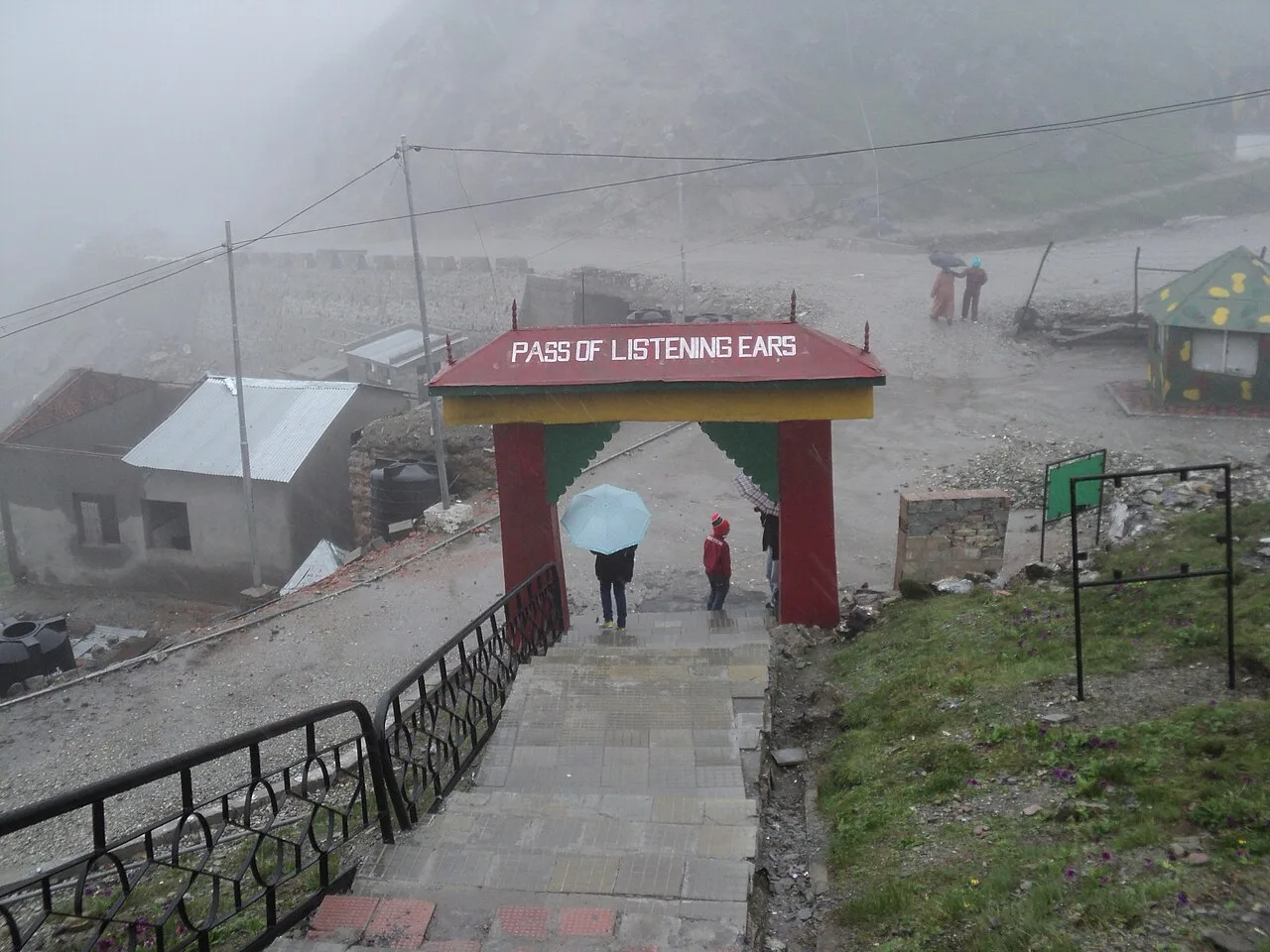
Nathu La
Nathu La is a high Himalayan pass on the Sikkim–Tibet frontier, known for its history of trade and strategic importance. Visitors also use it as a route towards Mount Kailash and Lake Manasarovar.
Key facts · verified by Ghumoopedia editors
- Type of place
- Natural attraction
- Best time to visit
- March to May and October to December; avoid the June–September monsoon
- Nearest railway station
- Siliguri Junction · about 85 km (straight line)
- Nearest airport
- Pakyong Airport (limited, weather-dependent flights) · about 30 km (straight line)
- Verified
- 21 Nov 2026
Plan a trip from Nathu La — a day-by-day route through places nearby.
Nathu La is in Sikkim’s Gangtok district. At 4,310 metres (14,140 feet), the pass crosses the Dongkya Range of the Himalayas, on the boundary between Sikkim and Yadong County in Tibet, China. Its route links Kalimpong and Gangtok with settlements in the lower Chumbi Valley. J. W. Edgar surveyed the pass in 1873 and noted its use by Tibetan traders. Francis Younghusband crossed it in 1903–04. A British diplomatic mission to Lhasa travelled through in 1936–37, followed by Ernst Schäfer in 1938–39. Trade from the Kingdom of Sikkim also passed through Nathu La during the 1950s. India and China closed the route after the 1962 Sino-Indian War. Tensions continued, and clashes in 1967 caused deaths on both sides. Nathu La is often compared with Jelep La, another mountain crossing 3 miles (4.8 kilometres) away. Improving relations eventually led to Nathu La reopening in 2006. This restored route offers another way to reach Mount Kailash and Lake Manasarovar for pilgrims. Its reopening was also expected to support the regional economy through greater trade between China and India. Cross-border commerce has had an overall positive effect, though it has not reached the expected scale. Trade is confined to certain categories of goods and takes place only on designated days. Heavy snowfall and other difficult weather restrict activity to about seven or eight months each year. Roads approaching the pass have been upgraded on both sides, and rail routes have been extended closer to it. Nathu La is included in south-east Sikkim’s domestic tourist circuit. Military personnel from India and China stationed here are among the closest to one another along their shared border. The pass is also one of five sites where the two armies hold Border Personnel Meetings. Sikkim is a small Himalayan state wrapped around Kangchenjunga, the world's third-highest peak, with Buddhist monasteries such as Rumtek, Pemayangtse and Tashiding, Lepcha, Bhutia and Nepali communities, high-altitude lakes like Tsomgo and Gurudongmar, rhododendron valleys at Yumthang and Varsey, and a strong commitment to organic farming and clean, plastic-light tourism. Weather depends on altitude: Gangtok and Pelling are mild in spring and autumn and cold in winter, while North Sikkim and Nathu La lie under snow from December to March. The monsoon (June to September) brings heavy rain and frequent landslides. Spring is rhododendron season; October and November give the clearest views of Kangchenjunga. The usual best time to visit is March to May and October to December; avoid the June–September monsoon. Timings, fees and access arrangements must be confirmed locally. For official information, see Sikkim Tourism at https://www.sikkimtourism.gov.in.
Why it matters
Nathu La is a high Himalayan pass in Sikkim’s Gangtok district, linking the Indian side of the border with Tibet’s Chumbi Valley. At 4,310 metres, it is both a mountain crossing and a strategically important part of the India–China frontier. The pass has long been associated with trade and travel across the Himalaya, and its reopening for limited border trade in 2006 renewed its regional economic role. It is also part of Sikkim’s domestic tourist circuit, often visited with Tsomgo Lake and nearby sites. The pass is an active, security-controlled border area, not a general international crossing. No UNESCO or ASI heritage designation is established for the pass.
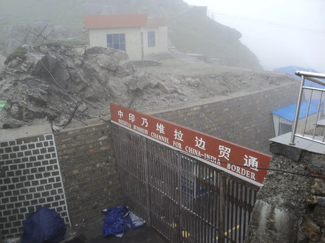
Nathu La is a natural Himalayan pass rather than a built monument. Its route across the Dongkya Range was used for movement and trade between Sikkim and Tibet. British surveyor J. W. Edgar described it in 1873 as a route used by Tibetan traders. Francis Younghusband travelled through the pass during the 1903–04 British expedition to Tibet; a British diplomatic delegation to Lhasa used it in 1936–37, and Ernst Schäfer’s expedition followed in 1938–39. Trade through the pass continued when Sikkim was a kingdom in the 1950s. After the 1962 Sino-Indian War, China and India sealed the pass diplomatically. Border tensions persisted, including clashes in 1967 that caused fatalities on both sides. Relations later improved, and Nathu La reopened in 2006 for regulated border trade. The reopening also created an alternative route for eligible Indian pilgrims travelling towards Mount Kailash and Lake Manasarovar, though it is not a general tourist crossing into Tibet. Trade remains restricted to approved goods and designated days, and seasonal snowfall can interrupt operations. Roads on both sides have been improved over time, while the pass remains a sensitive military and border area.
Origin stories & folklore
There is no single widely documented origin legend specific to Nathu La that can be presented as established local tradition. The name is commonly explained through Tibetan-language elements: “la” means pass, while “Nathu” is often interpreted as “listening ears.” This is a linguistic explanation, not a verified origin story. Across Himalayan communities, mountains and high passes may be treated with respect, and local Buddhist customs inform how people relate to the landscape. Visitors should avoid turning general beliefs into claims about a particular sacred site, and should follow posted rules and local guidance at this controlled border location.
Spend unhurried time at Nathu La: walk the marked paths, use official viewpoints and ask locally whether a guide, entry ticket or forest permission is needed. At this altitude, keep your stay short, walk slowly and avoid exertion — the air is thin and the cold is severe even in summer. A comfortable itinerary is one main visit in the morning, a local meal at midday and a short nearby stop before an afternoon return. In the mountains, mornings are clearest; clouds often roll in by noon, so start early for views of Kangchenjunga. Use the district list on this site to find other places in Gangtok, but check the route and its condition before combining stops. If a festival is on — such as Losar (Tibetan New Year), Saga Dawa, Pang Lhabsol, Losoong, Bumchu at Tashiding, Dasain and Tihar or the Gangtok winter carnival — roads and stays can be busy, and the experience can be unforgettable. Leave no litter: Sikkim restricts plastic and packaged water in many tourist areas, so carry a refillable bottle.
Suggested itineraries
Half day: Travel from Gangtok to Nathu La with a permitted operator (allow several hours each way); spend a short period on marked paths and at approved viewpoints; return to Gangtok. Full day: Set out early from Gangtok; visit Nathu La in the morning; stop at Tsomgo Lake if the route, permit and conditions allow; return to Gangtok for a meal and rest. Keep the schedule flexible for weather and checkpoints. Gentler option: From Gangtok, choose a shorter, lower-elevation outing instead of Nathu La, or remain in the vehicle and limit walking to accessible approved viewpoints if the operator confirms access.
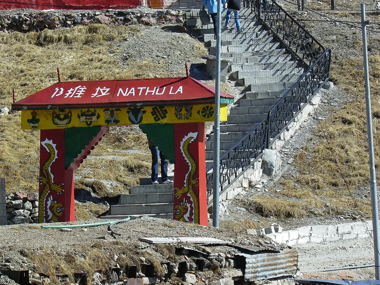
The pass sits within Sikkim’s culturally diverse setting, shaped by Lepcha, Bhutia and Nepali communities, as well as Tibetan Buddhist influences. Buddhist monasteries, prayer flags and religious observances are part of the wider regional landscape, though Nathu La itself is primarily a border and mountain destination. Nepali, Sikkimese languages and Tibetan are heard across the state, alongside Hindi and English in visitor-facing settings. Music, dance, clothing and customs vary between communities and occasions; visitors may encounter them more readily in Gangtok or at community events than at the pass. Keep a respectful distance from military activity and ask before photographing people.
Local communities
Lepcha, Bhutia and Nepali communities are among the communities with longstanding connections to Sikkim’s mountain landscapes and regional routes. The pass’s history also links it with Tibetan traders and communities in the Chumbi Valley, across the present international border. Today, local livelihoods around the visitor route include tourism, transport, hospitality and services in Gangtok and nearby settlements; agriculture and other work are important across the wider region. Border duties are carried out by military and government personnel. Nathu La is a controlled area, so visitors should not approach or photograph people at work without permission.
Festivals & events
Nathu La is not known as a regular festival venue. In Gangtok and elsewhere in Sikkim, Losar (Tibetan New Year) and Saga Dawa are observed according to the Buddhist calendar, while Pang Lhabsol and Losoong are important regional celebrations. Dasain and Tihar are also celebrated by many Nepali communities, generally in autumn. Gangtok’s winter carnival is another seasonal event. Dates vary by year, and celebrations take place at different venues rather than necessarily at the pass. Festivals can increase demand for rooms and transport in Gangtok, so check local conditions before planning a combined visit.
Local food in Sikkim includes momos, thukpa and thenthuk noodle soups, phagshapa (pork with radish), gundruk and sinki fermented greens, sel roti, churpi (yak cheese), chhurpi soup, local tea from Temi and warm tongba millet brew in the hills. Ask what is fresh that day; many small eateries cook a limited daily menu. Most food is mild compared with the plains, with plenty of vegetarian options; local chilli pastes made from dalle khursani are extremely hot, so try a little first. Hot soups and butter tea help at altitude. Remote sites may have no restaurant at all. Carry water and snacks, eat a proper breakfast before long drives, and ask your accommodation for a packed lunch if you are heading out early. Try a home-cooked or local thali meal when you can — it is often the best food on the route. Choose busy, clean places, drink sealed or filtered water, and carry your packaging back with you.
Shopping & local experiences
Nathu La is not a dependable shopping destination, and border-trade goods are not a general tourist market. For souvenirs, browse Gangtok’s markets and established shops for Sikkimese handicrafts, textiles, locally made products and packaged regional foods. Ask about the maker and materials, and avoid items made from protected wildlife or plants. Sikkim encourages reduced plastic use, so carry a reusable bag and bottle where practical. Food experiences are easier to find in Gangtok, where visitors can look for regional dishes and local produce; availability varies by season and establishment.
Nathu La crosses the high, cold Dongkya Range at about 4,310 metres. The exposed pass has a stark alpine landscape, with snow and ice possible in winter and vegetation becoming sparse at this elevation. Lower approaches include mountain slopes and forested areas, while Sikkim’s broader highland environment supports alpine plants, including seasonal flowering species. The pass is not a reliable place to see particular wildlife or birds; sightings depend on weather, season and disturbance. Conditions can change quickly, and heavy snowfall may restrict access. Stay on marked routes, do not disturb plants or animals, and take all rubbish back with you.
March to May and October to December; avoid the June–September monsoon
The nearest principal railway station by straight-line distance is Siliguri Junction, roughly 85 km away. The nearest operating airport by straight-line distance is Pakyong Airport (limited, weather-dependent flights), roughly 30 km away. These figures are calculated from map coordinates — actual road distance is longer, and mountain roads mean even short distances can take hours. Most travellers arrive at Bagdogra Airport or New Jalpaiguri (NJP) railway station near Siliguri in West Bengal, about 4–5 hours' drive from Gangtok; Pakyong Airport near Gangtok has limited, weather-dependent flights. Shared jeeps and reserved taxis run from Siliguri to Gangtok, Namchi, Ravangla and Pelling. Nathu La lies in a permit area: book a registered tour operator or taxi from Gangtok (or Mangan for the north) at least a day ahead so the Protected Area Permit can be processed, carry the original photo ID you applied with, and expect checkpost stops on the way. North Sikkim trips usually run as two- or three-day packages with an overnight in Lachung or Lachen. When comparing train, bus and flight, count the complete door-to-door time: a flight saves the most time only if the onward road transfer is short, while an overnight train can save a hotel night. For Sikkim, flying into Bagdogra saves the most time from distant cities, while a train to NJP is cheaper; either way the road journey up the Teesta valley takes most of a day, so do not plan sightseeing on arrival. Book your return before you leave, because seats fill quickly on weekends, festivals and holidays. Current train numbers, timings, return services and fares are not listed here; check IRCTC and NTES for trains and the airline's own schedule for flights. Indian travellers need no permit for Gangtok, Pelling, Namchi and Ravangla, but a Protected Area Permit — arranged through a registered Sikkim tour operator or taxi association with photo ID and passport photos — is mandatory for Tsomgo Lake, Nathu La, North Sikkim (Lachung, Lachen, Yumthang, Zero Point and Gurudongmar), Zuluk and the Dzongri–Goecha La trek. Foreign nationals need a free Restricted Area Permit, issued online or at the Rangpo and Melli checkposts, and cannot visit Nathu La; some areas allow foreigners only in groups. Nathu La is open on limited days each week and closes after snowfall, and landslides can shut any road at short notice.
Confirm onward and return timings on IRCTC / NTES, the state bus operator or your airline before travel. A dash means current timings or fares have not been verified.
Getting around
Most visitors travel from Gangtok towards Nathu La in a registered taxi or an organised vehicle, with permits arranged in advance. The mountain road is steep and weather-sensitive; vehicles may be stopped at checkpoints or turned back if conditions or security rules require it. Do not rely on local buses or autos for the pass itself. Walking is limited to designated areas once there, and parking or vehicle access may be controlled. Ask your operator about road conditions, approved stops and the return plan. Gangtok is the practical base for arranging transport and checking local updates.
Hours, tickets & permissions
Nathu La is in a controlled border area, and access depends on current security, weather and road conditions. Eligible visitors generally need an official permit, commonly arranged through a registered operator from Gangtok; rules can change, and foreign-national access is restricted or unavailable under prevailing regulations. Carry the identification documents requested during the application and at checkpoints. Do not assume that a permit guarantees access on a particular day. Confirm current entry requirements, operating arrangements and any fees with the relevant local authority or registered operator before setting out.
Facilities
Facilities at the pass are limited and may vary with weather and security arrangements. Check locally whether toilets, refreshments or other basic services are available on the day; do not count on reliable drinking-water refills or a medical facility at the site. Food, accommodation, ATMs and more dependable services are easier to find in Gangtok, which is the usual base. Parking and vehicle stopping are subject to local control. A registered operator can clarify what is open and what provisions to carry. Bring water, warm layers and any personal medication you may need.
Accessibility
The journey involves a long drive on a steep mountain road, and the high altitude can make even light activity tiring. The ground around the pass may be uneven, cold, snowy or icy, and visitors must keep to marked areas; walking distances and access can change with security controls. Wheelchair and stroller access should not be assumed, and steps or rough surfaces may present obstacles. Older visitors and anyone with heart or breathing conditions should seek medical advice before travelling to this elevation. A gentler alternative is to remain in Gangtok or choose a lower-altitude outing.
Indian travellers need no permit for Gangtok, Pelling, Namchi and Ravangla, but a Protected Area Permit — arranged through a registered Sikkim tour operator or taxi association with photo ID and passport photos — is mandatory for Tsomgo Lake, Nathu La, North Sikkim (Lachung, Lachen, Yumthang, Zero Point and Gurudongmar), Zuluk and the Dzongri–Goecha La trek. Foreign nationals need a free Restricted Area Permit, issued online or at the Rangpo and Melli checkposts, and cannot visit Nathu La; some areas allow foreigners only in groups. Nathu La is open on limited days each week and closes after snowfall, and landslides can shut any road at short notice. Carry a photo ID at all times and save the emergency number 112 and your accommodation's contact offline. Altitude sickness is the main risk: spend a night acclimatising in Gangtok and Lachung or Lachen before going higher, avoid alcohol, drink water, and descend immediately if you develop a severe headache, breathlessness or confusion. People with heart or lung conditions, young children and pregnant women should consult a doctor before going. Stay on marked paths, keep away from cliff edges and fast water, and never approach wild animals.
Photography
Clearer views are often more likely earlier in the day, although mountain weather can change quickly and clouds may obscure the scenery. Photograph only from authorised viewpoints and follow instructions from security personnel. Military facilities, checkpoints, border infrastructure and personnel may be off-limits to photography; check posted rules rather than assuming cameras are permitted everywhere. Drone use near an international border and military area is especially sensitive and should not be attempted without explicit official authorisation. Ask people before taking their portraits, and be respectful around prayer flags or any religious observance.
Choose a stay by the full journey to Nathu La, not just the district name. Permit-area trips usually include basic lodges in Lachung, Lachen or Zuluk; rooms are simple, heating is limited and power cuts are common, so carry warm layers and a torch. Nights are cold for much of the year — check heating, hot water and extra blankets. Book in advance for weekends, festivals and the peak season (March to May and October to December; avoid the June–September monsoon). Confirm the exact location, meals included, check-in time and cancellation terms in writing. Avoid sending money to unverified contacts or touts at stations. Carry some cash, as card and digital payments can be unreliable in remote areas.
Tsomgo Lake is a popular high-altitude stop on the approach from Gangtok, and many visitors combine it with Nathu La when permits and road conditions allow. The Baba Harbhajan Singh shrine is another commonly visited site on the route; observe local guidance and any access restrictions. Gangtok offers monasteries, viewpoints, markets and visitor services and is the usual base for the trip. These are mountain journeys, not quick urban detours: road conditions, permits and altitude affect how many stops are practical. Confirm the day’s route with a registered operator before combining destinations.
For couples, Nathu La rewards a slow pace: arrive early for soft light and fewer crowds, share a local meal and keep the evening free. Sunrise over Kangchenjunga from Pelling or Tashi View Point, a stroll on MG Marg in the evening or a quiet homestay night in a village makes the trip memorable. Public displays of affection can be frowned upon in conservative communities and at religious sites, so be discreet. Keep a buffer in your itinerary, because weather and road conditions can delay plans.
Q: How much time should I allow for a visit? A: Allow most of a day from Gangtok because the mountain drive takes time and access depends on permits, checkpoints and weather. Q: When is the best season to visit? A: Spring and autumn often offer more settled travel conditions, but snowfall, rain and sudden weather changes can affect access in any season. Confirm conditions before departure. Q: Do I need permission to enter Nathu La? A: Yes. It is a controlled border area; eligible visitors generally need a permit arranged through an authorised operator. Verify current rules before booking. Q: Is the visit suitable for children or elderly visitors? A: The high altitude, cold and lengthy drive can be demanding. Consider individual health and mobility, keep activity gentle, and seek medical advice if unsure. Q: Where should I stay nearby? A: Gangtok is the usual base, with a wider choice of accommodation, food and transport services than at the pass.
Be the first to share photos, stories, advice or a helpful contact for Nathu La.
Loading…