
Sandakphu
Sandakphu, also known as Sandakpur, is a 3,636-metre summit on the India–Nepal boundary. Visitors come for views of the Kangchenjunga range and several of the world's highest peaks.
Key facts · verified by Ghumoopedia editors
- Type of place
- Natural attraction
- Best time to visit
- October to March for the plains and coast; March to May and October to December for the Darjeeling hills
- Nearest railway station
- Darjeeling (toy train) · about 25 km (straight line)
- Nearest airport
- Bagdogra Airport (Siliguri) · about 55 km (straight line)
- Verified
- 21 Nov 2026
Plan a trip from Sandakphu — a day-by-day route through places nearby.
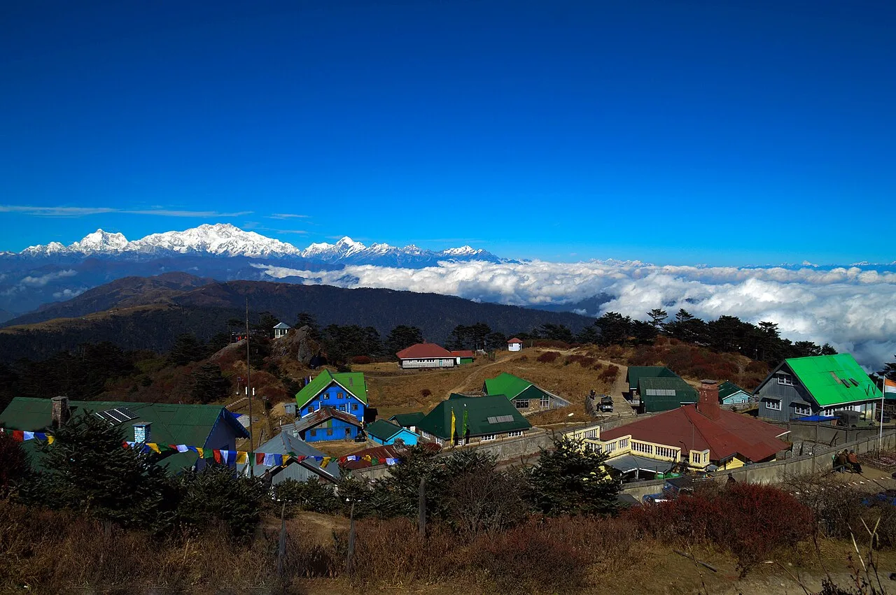
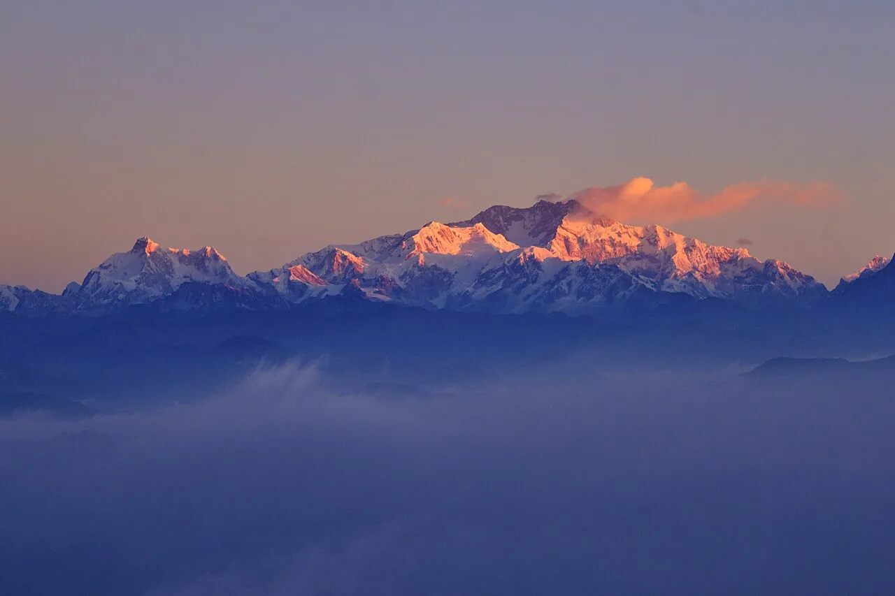
In West Bengal's Darjeeling district, Sandakphu stands on the Singalila Ridge, which runs along the India–Nepal border. At 3,636 m (11,929 ft), it is the ridge's highest point and the highest point in West Bengal. The summit lies beside Singalila National Park. A small village there has a few hotels. From the summit, the entire Kangchenjunga Range is visible. Four of the world's five highest peaks—Everest, Kangchenjunga, Lhotse and Makalu—can also be seen. Sandakphu is sometimes called the land of poisonous flowers. West Bengal stretches from the Himalayan tea gardens of Darjeeling to the mangrove delta of the Sundarbans, with Kolkata's colonial architecture, the terracotta temples of Bishnupur, Tagore's Santiniketan and the Nawabi heritage of Murshidabad. The plains are hot and humid from March to June, receive heavy monsoon rain from June to September and are pleasant from November to February; the Darjeeling hills are cool year-round and cold in winter, and the coast and Sundarbans can be hit by cyclones in May and October–November. The usual best time to visit is October to March for the plains and coast; March to May and October to December for the Darjeeling hills. Timings, fees and access arrangements must be confirmed locally. For official information, see West Bengal Tourism at https://wbtourism.gov.in.
Why it matters
Sandakphu, also called Sandakpur, is a 3,636-metre peak on the Singalila Ridge along the India–Nepal border. It is the highest point in the ridge and in the Indian state of West Bengal, making it a notable destination in the Darjeeling hills. The summit lies at the edge of Singalila National Park and has a small settlement with a few places to stay. In clear weather, the viewpoint can reveal four of the world’s five highest peaks—Everest, Kangchenjunga, Lhotse and Makalu—as well as the wider Kangchenjunga range. Its importance is chiefly geographic, scenic and linked to mountain trekking; no UNESCO or ASI designation for the summit is asserted here.
Sandakphu is a natural summit rather than a built monument, and there is no well-established record identifying a builder, founding date or major restoration. The ridge forms part of a long-standing mountain landscape used by local residents and travellers; the paths and settlements have developed in response to its terrain and cross-border setting. Accounts of the peak’s early use are limited, so specific claims about its origins should be treated cautiously. A major change in the area’s management came with the protection of the surrounding Singalila landscape. The protected area received national-park status in 1992. Conservation management, trekking and road access now shape how visitors experience the ridge. A small village and a few hotels occupy the summit, while the route is served by walking trails and, subject to local conditions and rules, high-clearance vehicles. These visitor arrangements can change with weather, road conditions and forest regulations. Sandakphu’s best-known historical significance remains its place in the region’s mountain geography, rather than an association with a documented fort, temple or royal building.
Origin stories & folklore
Sandakphu is sometimes called the “land of poisonous flowers.” This is a popular explanation associated with the mountain’s name and the poisonous plants said to grow in the wider Himalayan landscape; interpretations of the name vary, and a single definitive origin is not established. The sweeping outline of the Kangchenjunga peaks is also popularly likened to a sleeping figure, sometimes called the Sleeping Buddha. This is a way of reading the mountain silhouette, not a claim that the summit has a documented origin legend. Visitors may hear different versions from guides and residents, and should understand them as local or travel traditions rather than verified history.
Spend unhurried time at Sandakphu: walk the marked paths, use official viewpoints and ask locally whether a guide, entry ticket or forest permission is needed. Weather can change quickly, so carry a rain layer even on a clear morning. Wildlife sightings are never guaranteed — patience and quiet improve your chances. A comfortable itinerary is one main visit in the morning, a local meal at midday and a short nearby stop before an afternoon return. Use the district list on this site to find other places in Darjeeling, but check the route and its condition before combining stops. If a festival is on — such as Durga Puja, Kali Puja or the Poush Mela at Santiniketan — roads and stays can be busy, and the experience can be unforgettable. Leave no litter: many sites are protected by the communities around them.
Suggested itineraries
Half day: From your summit accommodation, take an easy walk to an accessible viewpoint (30–60 minutes), pause for the mountain panorama, then return for a meal and a short local path walk (1–2 hours); adapt to weather and energy. Full day: Begin with a viewpoint visit, walk a marked section of ridge or nearby trail with a local guide if required (2–4 hours), return for lunch, then spend the afternoon at another accessible viewpoint or resting in the village (2–3 hours). Check route conditions first. Gentler option: Choose a viewpoint close to your accommodation, sit for the views and return without attempting a longer trail. Reaching Sandakphu itself generally involves a substantial journey; do not treat these as day trips from Darjeeling town.

The summit is a small, remote settlement rather than a large cultural centre. Everyday life and visitor services reflect the broader Darjeeling hill region, where Nepali is widely spoken alongside Bengali, Hindi and other languages. On the approach, visitors may encounter Buddhist prayer flags and monasteries in nearby communities, as well as Hindu and Buddhist customs. Music, dance, clothing and food vary among families and communities; there is no single tradition that represents everyone on the ridge. Travellers can show respect by asking before photographing people, homes or religious observances, and by following local guidance on paths and protected areas.
Local communities
Residents and workers in the Sandakphu area and along its approach include people from Nepali-speaking hill communities, with livelihoods connected to small-scale hospitality, guiding, transport, trade and local services. Communities in the wider Darjeeling hills include people with varied ethnic, linguistic and religious backgrounds; identities and customs should not be treated as uniform. Some households also depend on farming and other rural work. Tourism can provide income, but the remote setting and seasonal weather make access and supplies challenging. Visitors can support local livelihoods by using locally run accommodation and services, respecting residents’ privacy and carrying out their rubbish.
Festivals & events
There is no major annual festival at the Sandakphu summit that can be confidently identified as a fixed visitor event. In nearby hill communities, Nepali Hindu festivals such as Dashain and Tihar are commonly observed in autumn, while Buddhist communities may mark Losar, usually in winter or early spring depending on local practice. Darjeeling town also celebrates Durga Puja, generally in autumn. Festival customs and dates vary from year to year and between communities. Stays and road transport in busier towns can be in greater demand around celebrations; check local arrangements rather than assuming that a festival programme takes place at the summit.
Local food in West Bengal includes macher jhol (fish curry), shorshe ilish (hilsa in mustard), kosha mangsho, luchi with alur dom, kathi rolls and phuchka in Kolkata, mishti doi, rosogolla and sandesh; in the Darjeeling hills, momos, thukpa, shaphaley and first-flush Darjeeling tea. Ask what is fresh that day; many small eateries cook a limited daily menu. Vegetarian travellers eat well across the state, and most towns also have fish and meat dishes. Remote sites may have no restaurant at all. Carry water and snacks, eat a proper breakfast before long drives, and ask your accommodation for a packed lunch if you are heading out early. Try a home-cooked or local thali meal when you can — it is often the best food on the route. Choose busy, clean places, drink sealed or filtered water, and carry your packaging back with you.
Shopping & local experiences
Shopping at Sandakphu is limited, so do not expect a large market or a broad range of souvenirs. Small local shops or lodges may offer snacks, basic supplies and simple keepsakes, depending on the season. In Darjeeling and other larger settlements, visitors can look for locally made woollens, handcrafts, tea and regional food products. Buying from local businesses can support residents, but check the origin and quality of goods rather than assuming every item is locally produced. Try local hill meals where available, and carry reusable containers where practical to reduce packaging waste in this remote landscape.
Sandakphu rises above forested slopes and open, exposed ridgelines in the eastern Himalaya. The wider Singalila landscape includes temperate and subalpine forest, bamboo, rhododendron, magnolia and other flowering plants; what is in bloom depends on elevation and season. The protected area provides habitat for wildlife including the red panda, Himalayan black bear and several other mammals, as well as a variety of birds. Birdlife may include pheasants and other Himalayan species, but sightings are never assured. The summit is known for broad mountain views when clouds and visibility allow, while weather can change quickly. Stay on established paths and follow park guidance to reduce disturbance to plants and wildlife.
October to March for the plains and coast; March to May and October to December for the Darjeeling hills
The nearest principal railway station by straight-line distance is Darjeeling (toy train), roughly 25 km away. The nearest operating airport by straight-line distance is Bagdogra Airport (Siliguri), roughly 55 km away. These figures are calculated from map coordinates — actual road distance is longer, and hill roads are slow. Howrah, Sealdah and Kolkata stations and Kolkata airport serve the south; New Jalpaiguri station and Bagdogra airport near Siliguri are the gateways to the Darjeeling hills and the Dooars. For the final leg, West Bengal Transport Corporation, North Bengal State Transport and South Bengal State Transport buses, private buses and shared jeeps in the hills link district towns. A private taxi gives more flexibility for remote sites. When comparing train, bus and flight, count the complete door-to-door time: a flight saves the most time only if the onward road transfer is short, while an overnight train can save a hotel night. Book your return before you leave, because seats fill quickly on weekends, festivals and holidays. Current train numbers, timings, return services and fares are not listed here; check IRCTC and NTES for trains and the airline's own schedule for flights. No permit is needed for Indian citizens to visit West Bengal. Entry to the Sundarbans Tiger Reserve needs a forest permit, usually arranged through a registered boat operator or the forest office at Sajnekhali or Canning; trekking in Singalila National Park (Sandakphu) needs an entry permit and a registered guide from Maneybhanjan. Durga Puja in October brings huge crowds to Kolkata, so book transport and stays well ahead.
Confirm onward and return timings on IRCTC / NTES, the state bus operator or your airline before travel. A dash means current timings or fares have not been verified.
Getting around
Sandakphu is reached from the hill-road network via the Manebhanjan area. The final approach is commonly made on foot or, where permitted and conditions allow, in a locally arranged high-clearance vehicle; ordinary taxis and autos should not be assumed to operate at the summit. Shared or private transport can be discussed with local operators, but availability depends on weather, road condition and current access rules. Walking between nearby viewpoints is possible for visitors comfortable with uneven mountain paths. Parking and vehicle access may be limited, so confirm arrangements before departure and allow flexibility for delays.
Hours, tickets & permissions
Access is affected by the rules for the protected landscape and by changing weather and road conditions. Visitors may need to follow forest entry procedures, obtain permission or use an authorised guide or vehicle, depending on current regulations and the route. Requirements can differ for trekking, vehicle access and photography equipment. Carry suitable identification and ask locally about any applicable restrictions before setting out. There is no reliable general schedule or fee information to give here; confirm current access rules, hours and fees with the managing forest authority or local operators before travel.
Facilities
Facilities at the summit are limited. A few hotels or lodges and simple meal options are available, but services and supplies can vary with season and weather. Toilets may be available at accommodation or local businesses; do not assume public facilities are open or accessible. Ask about safe drinking water and carry what you need, as reliable refills may be limited. There is no reason to expect an ATM, medical centre or extensive parking at the summit. Guides and vehicle arrangements are usually organised through local operators, particularly in the approach area. Check locally before relying on any facility.
Accessibility
Sandakphu is a high mountain destination with uneven, steep and sometimes muddy or icy paths, and the final approach may involve rough roads. Walking distances and gradients vary by route and viewpoint. Shade and shelter can be limited on exposed sections, while weather and altitude can make exertion harder. The area is not generally suitable for wheelchair or stroller use, and older visitors or anyone with mobility, heart or breathing conditions should assess the journey carefully and seek medical advice where appropriate. Vehicle access may reduce some walking but does not make every viewpoint accessible. Rest often, carry warm layers and avoid pushing on in poor conditions.
No permit is needed for Indian citizens to visit West Bengal. Entry to the Sundarbans Tiger Reserve needs a forest permit, usually arranged through a registered boat operator or the forest office at Sajnekhali or Canning; trekking in Singalila National Park (Sandakphu) needs an entry permit and a registered guide from Maneybhanjan. Durga Puja in October brings huge crowds to Kolkata, so book transport and stays well ahead. Carry a photo ID at all times and save the emergency number 112 and your accommodation's contact offline. Sandakphu is about 3,600 m above sea level: ascend gradually, watch for headache, nausea or breathlessness (altitude sickness), and descend if symptoms worsen. Nights are freezing in winter. Stay on marked paths, keep away from cliff edges and fast water, and never approach wild animals.
Photography
Clear mornings can offer strong light on the Himalayan panorama, but cloud, haze and changing weather often affect visibility. Use established viewpoints and allow time for conditions to shift rather than relying on a particular view. Ask permission before photographing residents, workers or private homes, and be discreet around religious sites and ceremonies. Follow park rules for cameras and equipment. Drone use may be restricted or require permission in protected and border areas; do not fly without confirming the current rules with the relevant authorities. Avoid leaving paths or disturbing wildlife for a photograph.
Choose a stay by the full journey to Sandakphu, not just the district name. Darjeeling, Kalimpong and Kurseong offer hotels and family homestays; in smaller hill villages, homestays are the main option and should be booked ahead. In the hills, check heating, hot water and power backup, and expect cold nights from November to February. Book in advance for weekends, festivals and the peak season (October to March for the plains and coast; March to May and October to December for the Darjeeling hills). Confirm the exact location, meals included, check-in time and cancellation terms in writing. Avoid sending money to unverified contacts or touts at stations. Carry some cash, as card and digital payments can be unreliable in remote areas.
The Sandakphu route passes through or near small settlements and viewpoints including Manebhanjan, Tumling, Gairibas and Kalipokhri; conditions determine which stops are practical. Tonglu is another well-known viewpoint on the Singalila trekking route, while Phalut is a farther ridge destination that generally needs separate route planning. Darjeeling town offers attractions such as the Himalayan Mountaineering Institute, Ghoom Monastery and Batasia Loop. These places are not all convenient for a same-day combination with Sandakphu: hill roads are slow, and the summit journey commonly requires substantial travel planning. Check route conditions before combining stops.
For couples, Sandakphu rewards a slow pace: arrive early for soft light and fewer crowds, share a local meal and keep the evening free. A toy-train ride in the Darjeeling hills, a boat on the Hooghly at sunset or an evening of adda over tea in Kolkata makes the trip memorable. Public displays of affection can be frowned upon in conservative communities and at religious sites, so be discreet. Keep a buffer in your itinerary, because weather and road conditions can delay plans.
Q: How much time should I allow for Sandakphu? A: Allow for a substantial journey to the summit and time to adjust to the altitude. A brief visit to viewpoints is possible once there, but the approach is not usually a simple stop from Darjeeling town. Q: When is a good season to visit? A: March to May and October to December are commonly favoured for the Darjeeling hills. Conditions vary, and clear mountain views are never guaranteed. Q: Is there an entry ticket or permit? A: Forest permissions or other access rules may apply. Confirm current requirements and any fees with the managing authority or local operator before setting out. Q: Is Sandakphu suitable for children or elderly visitors? A: The altitude, rough paths and long mountain journey can be demanding. Choose only a suitable route, allow plenty of rest and consider individual health and mobility. Q: Can I stay near the summit? A: A small village has a few hotels or lodges, but availability and facilities are limited. Confirm a booking and travel arrangements locally, especially in busy periods.
Be the first to share photos, stories, advice or a helpful contact for Sandakphu.
Loading…