
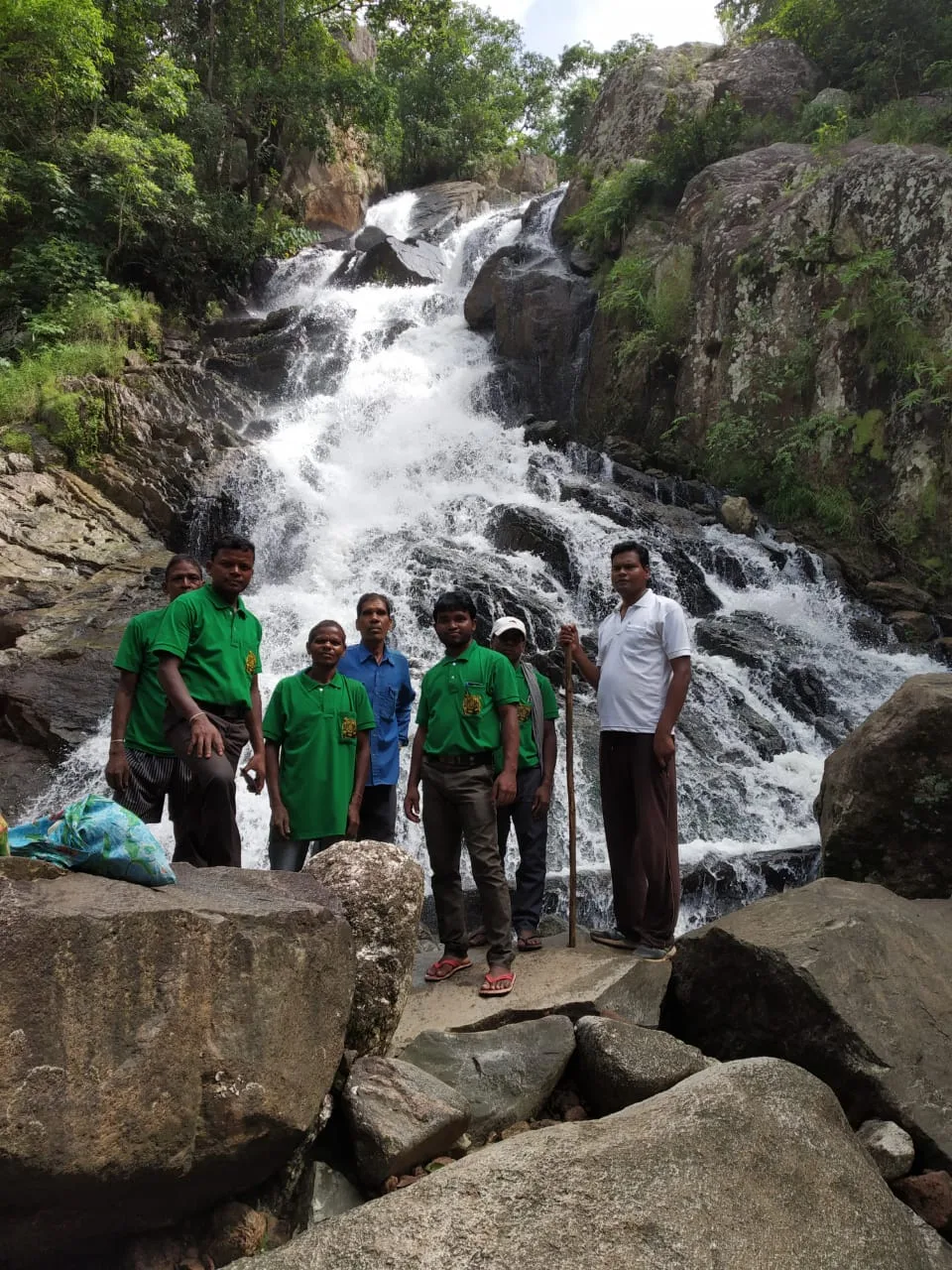
Lower Ghaghri Falls
Lower Ghaghri Falls is a 320-foot cascade in Latehar district, Jharkhand, about 10 kilometres from Netarhat. Visitors come to see the waterfall and its forest surroundings.
Key facts · verified by Ghumoopedia editors
- Type of place
- Natural attraction
- Best time to visit
- October to February for sightseeing; July to September for waterfalls at full flow (expect slippery paths)
- Nearest railway station
- Daltonganj · about 60 km (straight line)
- Verified
- 21 Nov 2026
Plan a trip from Lower Ghaghri Falls — a day-by-day route through places nearby.
In Latehar district, Jharkhand, Lower Ghaghri Falls lies about 10 kilometres from Netarhat. Its water descends 320 feet (98 metres), making it the 33rd-highest waterfall in India. The falls are on the Ghaghri River, a tributary of the Auranga River. Dense forest surrounds the cascade, with thick growth restricting the sunlight that reaches through. The sound of the falling water carries across the surroundings. Upper Ghaghri Falls is a smaller waterfall, 4 kilometres from Netarhat and below Netarhat Dam. Lower Ghaghri Falls attracts visitors as a natural attraction in Jharkhand, with its wooded setting and substantial drop. Jharkhand is the land of forests, waterfalls and Adivasi communities such as the Santhal, Ho and Munda, with major pilgrimages at Baidyanath Dham (Deoghar) and Shikharji (Parasnath). Jharkhand has hot summers from March to June, a monsoon from June to September when the waterfalls are at their fullest, and cool winters from November to February; the Netarhat plateau stays pleasant for much of the year. The usual best time to visit is October to February for sightseeing; July to September for waterfalls at full flow (expect slippery paths). Timings, fees and access arrangements must be confirmed locally. For official information, see Jharkhand Tourism at https://www.jharkhandtourism.gov.in.
Why it matters
Lower Ghaghri Falls is a natural attraction near Netarhat in Latehar district, Jharkhand. The main source describes it as about 10 kilometres from Netarhat and places it on the Ghaghri River, a tributary of the Auranga. Its forested setting and falling water make it a notable stop for visitors exploring the Netarhat plateau. The public encyclopaedia reference describes the cascade as 98 metres high and ranks it among India’s highest waterfalls; rankings can differ according to measurement and source. It is part of Jharkhand’s wider landscape of forests and waterfalls, which supports nature-based tourism.
Lower Ghaghri Falls is a natural feature rather than a structure known to have been built by people. The available public account identifies the Ghaghri River as its source and the Auranga as the river to which the Ghaghri is tributary. Water flowing over the local terrain has shaped the cascade over time, but a documented geological formation date is not available in the cited guide. Nor does the source establish a named builder, a specific founding period, or a recorded historic event at the falls. The forested setting is an important part of the attraction, and visitors should follow any current local guidance intended to protect the site and its surroundings. Netarhat and its plateau have become destinations for visitors seeking cooler upland scenery and natural viewpoints, with Lower Ghaghri Falls included in trips from the town. The nearby Upper Ghaghri Falls is a separate, smaller waterfall below Netarhat Dam. For a fuller account of local history, ask district or community sources rather than treating unverified stories as established fact.
Origin stories & folklore
As with many waterfalls and forest places, visitors may encounter local stories or beliefs connected with the landscape, but these can vary between communities and should not be presented as a single, verified account. The falls’ sound, secluded setting and seasonal changes may inspire personal interpretations, rather than evidence of a particular myth. If residents share a story, listen respectfully and ask whether it is appropriate to repeat or photograph related practices. Avoid entering places that local people identify as private, sacred or restricted.
Spend unhurried time at Lower Ghaghri Falls: walk the marked paths, use official viewpoints and ask locally whether a guide, entry ticket or forest permission is needed. Enjoy the water from safe, marked points; rocks near falls are slippery and currents are dangerous, especially in the monsoon — never swim below a waterfall. Wildlife sightings are never guaranteed — patience and quiet improve your chances. A comfortable itinerary is one main visit in the morning, a local meal at midday and a short nearby stop before an afternoon return. Use the district list on this site to find other places in Latehar, but check the route and its condition before combining stops. If a festival or fair is on — such as the Shravani Mela at Deoghar or Sarhul — roads and stays can be busy, and the experience can be unforgettable. Leave no litter: many sites are protected by the communities around them.
Suggested itineraries
Half day: From Netarhat, travel to Lower Ghaghri Falls; spend about 1–2 hours walking permitted paths and viewing the cascade; return to town for a meal. Full day: Visit Lower Ghaghri Falls in the morning; return to Netarhat for lunch; choose a short local viewpoint or the Upper Ghaghri Falls if access and road conditions allow; return before dusk. Gentler option: Arrange vehicle drop-off as close as locally permitted, enjoy the safest accessible viewpoint without descending toward the water, and allow extra rest time.
The falls are visited as part of trips to Netarhat and the wider Latehar region, where everyday cultural life reflects the diversity of Jharkhand. Hindi is widely useful for visitors; regional languages and speech varieties may also be heard, depending on the village and family. Music, dance, seasonal gatherings and customary forms of dress vary among communities, so there is no single tradition that can be assigned to the waterfall itself. Visitors can support local hospitality by asking before photographing people, observing community guidance and keeping the forest clean. The waterfall is a natural outing, not a staged cultural performance.
Local communities
People living in and around the Netarhat plateau and Latehar district have varied livelihoods, which may include farming, forest-related work, small businesses, transport and tourism services. Jharkhand is home to Adivasi communities including the Santhal, Ho and Munda, but this does not establish that every group is locally represented at the falls. Ask residents how they describe their own community and avoid assuming that customary knowledge or forest use is open to visitors. Buying food or services locally, seeking permission for photographs and following guidance about forest access are considerate ways to engage.
Festivals & events
Sarhul, a spring festival associated with nature and community traditions in parts of Jharkhand, and other regional observances may affect travel in the wider area; practices differ between communities. The Shravani Mela is held around Baidyanath Dham in Deoghar, farther away, and is not a festival at Lower Ghaghri Falls. No regular fair at the waterfall is confirmed by the available information. During prominent festival periods, roads, public transport and accommodation in popular towns may be busier than usual. Check locally before planning a visit around a celebration, and attend only public events where visitors are welcome.
Local food in Jharkhand includes dhuska, rugra (bamboo shoot and mushroom dishes), handia (rice beer, offered by tribal communities), litti, arsa roti, pittha, chilka roti and mahua-based preparations. Ask what is fresh that day; many small eateries cook a limited daily menu. Vegetarian travellers eat very well across this region, and most towns also have non-vegetarian options. Remote sites may have no restaurant at all. Carry water and snacks, eat a proper breakfast before long drives, and ask your accommodation for a packed lunch if you are heading out early. Try a home-cooked or dhaba meal when you can — it is often the best food on the route. Choose busy, clean places, drink sealed or filtered water, and carry your packaging back with you.
Shopping & local experiences
There is no confirmed dedicated souvenir market at the waterfall, and on-site shopping may be limited. Netarhat or larger district towns are more practical places to look for everyday supplies and locally made goods. Depending on availability, visitors may find regional crafts or small items made by local artisans; ask about their origin and buy directly from makers where possible. Try food from local eateries as an alternative to packaged snacks, and carry reusable water containers where safe refill points are available. Avoid buying wildlife products, plants or items presented as collected from the forest.
The falls lie in a forested setting near Netarhat. The source describes the surrounding forest as dense and identifies the Ghaghri River as a tributary of the Auranga River. The cascade is reported as about 98 metres high, though measurements may vary by method and reference. Water volume changes with the season: monsoon rains generally strengthen flows, while conditions can be different in drier months. Forest vegetation provides habitat for wildlife and birds, but sightings are never guaranteed. Keep noise low, stay on permitted paths and do not feed animals or remove plants. Wet rock, strong currents and sudden changes in water conditions make the stream edge hazardous, especially during and after heavy rain.
October to February for sightseeing; July to September for waterfalls at full flow (expect slippery paths)
The nearest principal railway station by straight-line distance is Daltonganj, roughly 60 km away. The nearest operating airport by straight-line distance is Birsa Munda Airport, Ranchi, roughly 110 km away. These figures are calculated from map coordinates — actual road distance is longer. Ranchi, Dhanbad, Tatanagar (Jamshedpur), Bokaro and Gomoh are the main rail gateways, and Ranchi, Deoghar and Durgapur have airports. For the final leg, Jharkhand State Transport buses, private buses and shared Sumo and Bolero jeeps link district towns; shared jeeps usually leave early in the morning. A private taxi gives more flexibility for remote sites. When comparing train, bus and flight, count the complete door-to-door time: a flight saves the most time only if the onward road transfer is short, while an overnight train can save a hotel night. Book your return before you leave, because seats fill quickly on weekends, festivals and holidays. Current train numbers, timings, return services and fares are not listed here; check IRCTC and NTES for trains and the airline's own schedule for flights. No permit is needed to visit Jharkhand. Some forest and mining areas have check posts, and a few interior pockets are affected by Left-wing extremism — check current advisories with your host or the district administration before travelling to remote areas, and avoid travelling on isolated roads after dark.
Confirm onward and return timings on IRCTC / NTES, the state bus operator or your airline before travel. A dash means current timings or fares have not been verified.
Getting around
Netarhat is the practical base for reaching the falls. Visitors can arrange a local taxi or private vehicle for the road journey and ask locally about the final approach, road condition and permitted drop-off or parking points. Shared vehicles may serve routes between district towns and the plateau, but onward transport to the falls should be confirmed in advance. The last part of a visit may involve walking on uneven paths. Autos may be available in larger settlements, but should not be relied on for every part of this rural route. Carry drinking water and plan the return journey before leaving Netarhat.
Hours, tickets & permissions
Entry arrangements can change with weather, forest management and local safety decisions. A ticket, guide, camera permission or forest approval may be required, or access may be restricted at certain times; none should be assumed without checking. Confirm current opening arrangements, fees and any identification or conduct rules with the relevant local managing authority or tourism office before setting out. Do not pass barriers or enter closed areas. Monsoon conditions may also affect whether paths are considered safe, even when the site is otherwise accessible.
Facilities
Facilities at the waterfall may be limited or seasonal. Do not assume that toilets, drinking-water points, food stalls, staffed information desks or guides are available on site; check locally before departure. Netarhat is the more practical place to arrange meals, supplies and transport. Parking may be informal or limited, so follow local directions and do not block access roads. ATMs and reliable mobile connectivity can be limited in rural areas; carry essentials from a larger town. Take all rubbish back with you and avoid relying on on-site shops for necessities.
Accessibility
The approach and viewing areas may include uneven ground, forest paths, slopes or slippery rocks, and the exact condition can change after rain. Walking distance depends on the permitted route and vehicle drop-off point; ask locally before committing. Older visitors and anyone with balance, mobility or heart concerns may find the terrain tiring. A companion, sturdy footwear and frequent rests can help, but do not attempt steep or wet sections if they feel unsafe. Stay well back from the water’s edge.
No permit is needed to visit Jharkhand. Some forest and mining areas have check posts, and a few interior pockets are affected by Left-wing extremism — check current advisories with your host or the district administration before travelling to remote areas, and avoid travelling on isolated roads after dark. Carry a photo ID at all times and save the emergency number 112 and your accommodation's contact offline. Heat in summer and fog in winter are the main weather risks; carry water and allow extra travel time on foggy December–January mornings. Waterfalls are dangerous in the monsoon: keep behind barriers, never enter the water near a fall, and leave the area if the water level rises suddenly. Follow local guidance if access changes.
Photography
Soft morning light can suit forest and waterfall photographs, while overcast conditions may reduce harsh contrast; seasonal flow and weather affect the scene. Use only official or clearly permitted viewpoints, and keep a safe distance from wet rocks and the edge. Check locally whether photography or camera equipment requires permission. Drone use may be restricted by aviation rules, forest management or local safety directions, so do not fly without confirming authorisation. Ask before photographing residents, workers or community activities, and do not interrupt rituals or enter private areas for a picture.
Choose a stay by the full journey to Lower Ghaghri Falls, not just the district name. Ranchi, Jamshedpur and Deoghar offer the widest choice; forest rest houses near the sanctuaries must be booked through the forest department. In summer, check air-conditioning or coolers; in December and January, check hot water. Book in advance for weekends, festivals and the peak season (October to February for sightseeing; July to September for waterfalls at full flow (expect slippery paths)). Confirm the exact location, meals included, check-in time and cancellation terms in writing. Avoid sending money to unverified contacts or touts at stations. Carry some cash, as card and digital payments can be unreliable in remote areas.
Netarhat is the natural base for combining the falls with other plateau scenery. The smaller Upper Ghaghri Falls is another waterfall near Netarhat, below Netarhat Dam; confirm access and conditions before adding it to a route. Netarhat’s viewpoints, including Magnolia Point and Koel View Point, are commonly associated with visits to the area. Farther afield in Latehar district, Betla National Park and the Palamu Forts are notable attractions, but they require separate route planning and should not be treated as immediate neighbours. Check road conditions and available daylight before combining several stops.
For couples, Lower Ghaghri Falls rewards a slow pace: arrive early for soft light and fewer crowds, share a local meal and keep the evening free. A waterfall viewpoint after the monsoon or a sunset from a hill temple makes the trip memorable. Public displays of affection can be frowned upon in conservative communities and at religious sites, so be discreet. Keep a buffer in your itinerary, because weather and road conditions can delay plans.
Q: How much time should I allow for Lower Ghaghri Falls? A: A half-day outing from Netarhat is a reasonable plan, with extra time for the road approach and walking. Q: When is the best season to visit? A: October to February is generally suitable for sightseeing; July to September often brings fuller water, but paths can be slippery and conditions hazardous. Q: Is there an entry ticket or permit? A: Requirements can change. Confirm current entry, fee and forest-permission rules with the local managing authority before travelling. Q: Is the falls suitable for children or elderly visitors? A: Families should supervise children closely and stay away from the water’s edge. Uneven, potentially slippery terrain may be difficult for some older visitors or people with limited mobility. Q: Where should I stay nearby? A: Netarhat is the most practical base for a visit. Check current accommodation availability there or in a larger town before setting out.
Be the first to share photos, stories, advice or a helpful contact for Lower Ghaghri Falls.
Loading…