
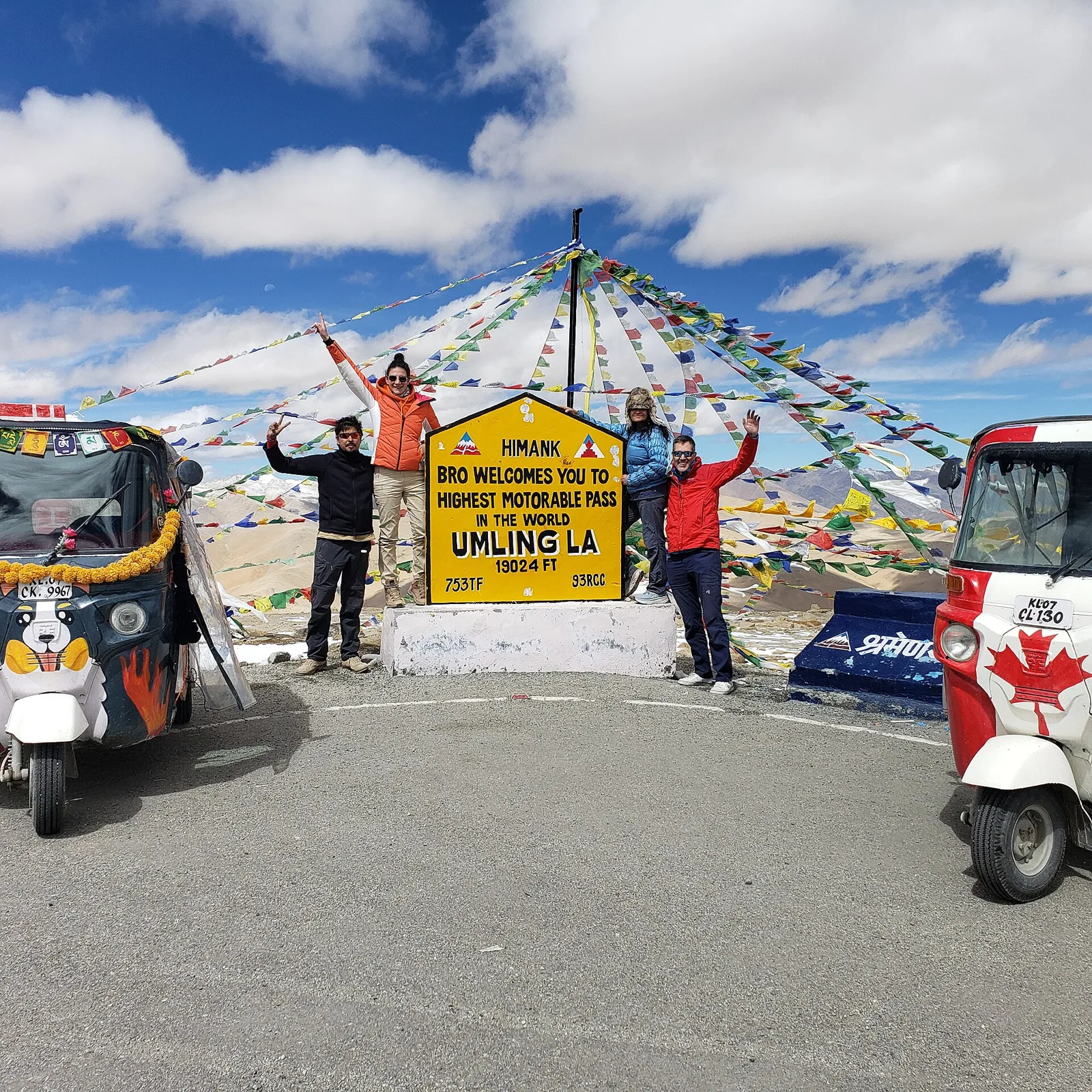
Umling La
At 5,799 metres, Umling La is a pass in Ladakh’s Changthang region near Demchok. Travellers use its high-altitude road linking Chisumle and Demchok.
Key facts · verified by Ghumoopedia editors
- Type of place
- Natural attraction
- Best time to visit
- June to September; October for clear skies with colder nights; January–February only for winter trips such as the Chadar trek
- Nearest railway station
- Chandigarh Junction · about 320 km (straight line)
- Verified
- 21 Nov 2026
Plan a trip from Umling La — a day-by-day route through places nearby.
Also written Umlung La, the pass rises to 19,024 feet (5,799 m) in Ladakh’s Changthang area, close to Demchok. It lies on a ridge separating Koyul Lungpa from the Indus River. The Umlung stream begins at the pass and flows into the Indus. A tributary of the Kiungdul river also originates here and drains towards Koyul Lungpa. Umling La Road crosses the pass on the route between Chisumle and Demchok. From 2017 until 2025, the road held the title of the world’s highest motorable road. It was overtaken by the higher Mig La crossing in India, at 19,400 feet (5,900 m). The pass thus sits at a divide between drainage towards the Indus and Koyul Lungpa. Ladakh is a high-altitude desert between the Karakoram and the Great Himalaya, with Tibetan Buddhist monasteries such as Hemis, Thiksey, Diskit and Lamayuru, the Shia and Balti culture of Kargil and Turtuk, the Brokpa villages of Dha-Hanu, the turquoise lakes Pangong Tso and Tso Moriri, and some of the world's highest motorable passes. Summers (June to September) are sunny and dry, with warm days and cold nights; winters are long and severe, often far below −15 °C, and the high passes close with snow. The sun is intense at this altitude, and weather on the passes can change within an hour. The usual best time to visit is June to September; October for clear skies with colder nights; January–February only for winter trips such as the Chadar trek. Timings, fees and access arrangements must be confirmed locally. For official information, see Ladakh Tourism at https://tourism.ladakh.gov.in.
Why it matters
Umling La, also called Umlung La, is a high mountain pass in Ladakh’s Changthang region, near Demchok. At about 19,024 feet (5,799 metres), it is a notable geographical point on the ridgeline separating Koyul Lungpa from the Indus River valley. Water from the pass feeds the Umlung stream, which drains towards the Indus, and a tributary flowing towards Koyul Lungpa. The road across the pass links Chisumle and Demchok and has brought attention to this remote border region. It held the title of the world’s highest motorable road from 2017 until a higher road over Mig La surpassed it in 2025. No UNESCO or ASI designation is established here.
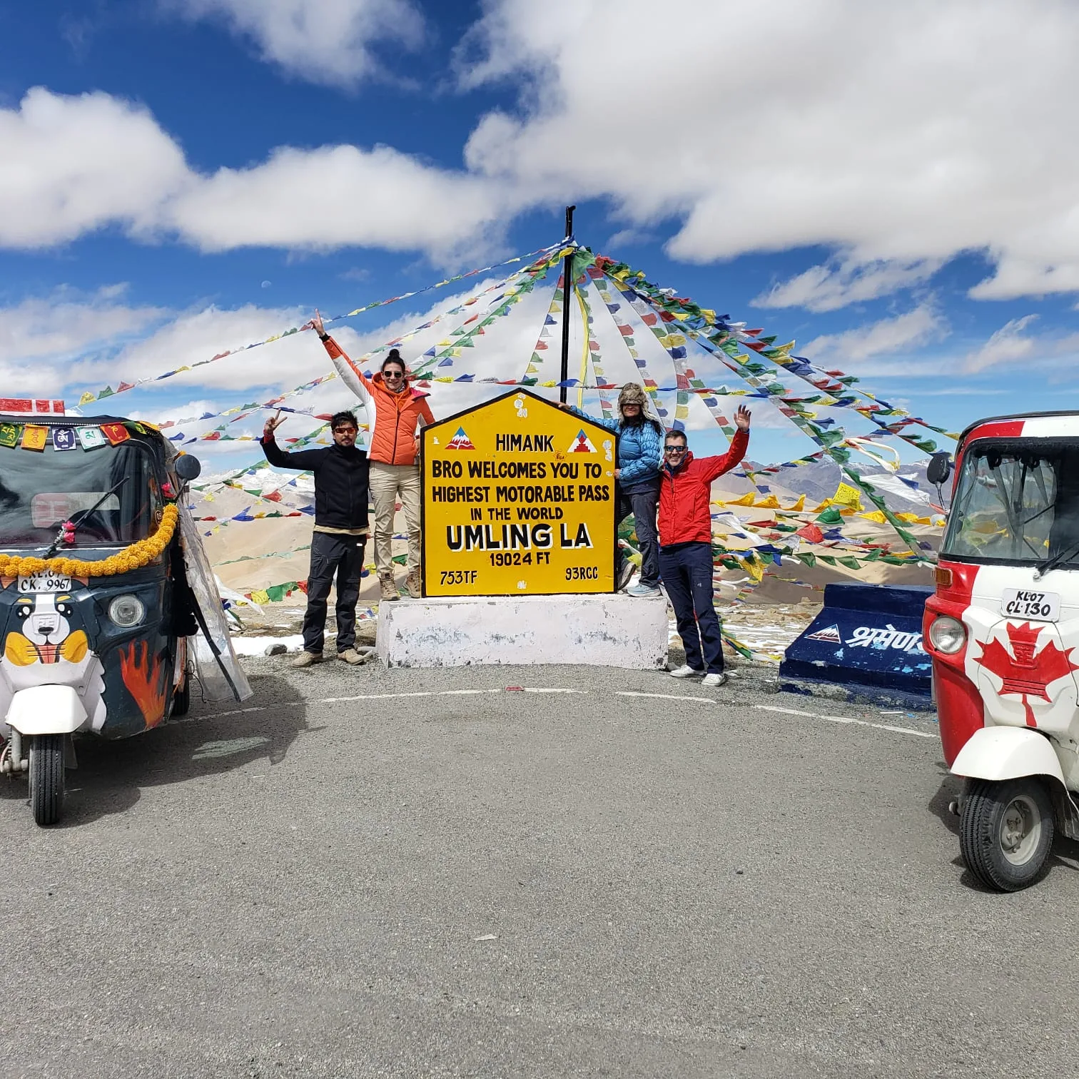
Umling La is a natural pass rather than a built monument, so its geological formation predates recorded travel history. It lies in the high-altitude Changthang landscape, where routes between valleys and settlements have long mattered to residents and pastoralists. The pass’s modern profile is closely connected with the road linking Chisumle and Demchok. The road was developed by the Border Roads Organisation, improving vehicle access across terrain that remains remote and environmentally demanding. Published accounts record that the route held the title of the world’s highest motorable road from 2017 until a higher motorable road over Mig La took that distinction in 2025. The road is not a guarantee of year-round access: snow, weather, road conditions and border-area controls can affect travel. Umling La has no known historic fort, monastery or monument whose construction or restoration defines the site. Visitors should distinguish the pass’s long-standing geographical importance from the more recent publicity around road access and elevation records. For the latest account of road status and permissions, check with local authorities before setting out.
Origin stories & folklore
No widely documented origin legend specific to Umling La is established in the available guide. The pass is best understood first as a high mountain crossing and watershed in Changthang, rather than as a site with a verified founding story. As elsewhere in Ladakh, local knowledge of mountains, streams and travel routes may be carried through family and community storytelling; accounts can vary and should be heard from residents with respect. Visitors should not present an unverified story as established fact or seek out restricted sacred knowledge. The pass’s reputation as a record-setting road belongs to recent travel history, not to an ancient legend.
Spend unhurried time at Umling La: use marked paths and official viewpoints, and ask locally whether a guide, ticket or permission is needed. At this altitude, keep your stay short, walk slowly and avoid exertion — the air is thin and the cold is severe even in summer. A comfortable itinerary is one main visit in the morning, a local meal at midday and a short nearby stop before an afternoon return. Start early: high passes are clearer and safer in the morning, and wind rises in the afternoon at lakes such as Pangong. Use the district list on this site to find other places in Changthang, but check the route and its condition before combining stops. If a festival is on — such as Hemis Tsechu in summer, Losar in winter, the Ladakh Festival in September or a monastery masked-dance festival — transport and stays can be busy, and the experience can be unforgettable. Ladakh's water is scarce and its waste is hard to remove — refill bottles at water points, use dry toilets as instructed and carry your rubbish back to Leh.
Suggested itineraries
Half day: From a locally confirmed overnight base, drive to an approved viewpoint, spend a short time taking in the landscape, then return; allow a brief stop rather than a strenuous walk. The road journey can make this unsuitable as a half-day outing from Leh. Full day: Set out early with a locally arranged driver, follow the approved route via Chisumle or Demchok as confirmed, pause briefly at safe viewpoints, have food and water arranged in advance, then return before conditions worsen. Gentler option: Remain in the vehicle, stop only at a safe viewpoint if permitted, and keep time outside short; anyone feeling unwell should descend and seek local help.
Umling La is not a town or monastery with a resident cultural programme; its cultural context comes from Changthang and nearby settlements. Ladakh’s traditions include Tibetan Buddhist practice, seasonal observances, communal gatherings, local music and masked dances at some monasteries. Ladakhi and related Tibetan languages are spoken across the region, alongside Hindi and other languages used by residents and visitors. Customs and dress differ between communities, so visitors should follow local guidance, ask before photographing people, and behave quietly at religious places. Festivals in Leh or at distant monasteries are not necessarily celebrated at the pass itself, and travel to them requires separate planning.
Local communities
People connected with the wider Changthang region include residents of villages such as Demchok and Chisumle, as well as pastoral communities whose livelihoods may involve livestock and seasonal movement. Changpa pastoralists are associated with parts of Changthang, though visitors should not assume every household near the pass belongs to the same community or follows the same way of life. Other livelihoods in the wider region include public services, road work and tourism-related work. The border setting shapes access and daily travel. Ask permission before photographing residents, homes, livestock or work, and follow local directions about where visitors may go.
Festivals & events
Umling La itself is not known as a festival venue, and there is no regular public fair established at the pass. In the wider Ladakh region, Losar, the Tibetan New Year, is generally observed in winter; monastery festivals and masked dances take place at different sites, often during warmer months. Hemis Tsechu is held at Hemis Monastery, while the Ladakh Festival is associated with Leh, not Umling La. Dates vary by local calendar and yearly announcements. Festival travel can make transport and accommodation busier in the places hosting events; these celebrations should be planned as separate outings rather than assumed to be stops on a pass visit.
Local food in Ladakh includes thukpa and skyu noodle soups, steamed momos, tingmo bread, paba and tsampa (roasted barley), chhurpi cheese, butter tea (gur gur cha), apricot jam and dried apricots from Kargil and Turtuk, seabuckthorn juice and, in Kargil and Drass, Balti and Kashmiri dishes. Ask what is fresh that day; many small eateries cook a limited daily menu. Leh's Main Bazaar and Changspa road have cafés for every taste, but outside Leh menus are short and simple. Eat light for the first two days while you acclimatise, avoid alcohol, and drink plenty of warm water and soups. Remote sites may have no restaurant at all. Carry water and snacks, eat a proper breakfast before long journeys, and ask your accommodation for a packed lunch if you are heading out early. Try a home-cooked or local meal when you can — it is often the best food on the route. Choose busy, clean places, drink sealed or filtered water, and carry your packaging back with you.
Shopping & local experiences
There is no established market or souvenir shop at Umling La, so plan purchases in Leh or another larger settlement before travelling. In Ladakh, visitors may find locally made woollen goods, handicrafts and packaged regional foods, but check the maker and provenance rather than assuming an item is locally produced. Buying directly from artisans or reputable shops can support local livelihoods. Food options at the pass should not be expected; arrange meals and drinking water in advance. Avoid collecting stones, plants or other natural material, and carry reusable bottles and packaging back out.
Umling La sits in a very high, cold-desert landscape of bare ridges, open slopes and wide views across Changthang. Vegetation is sparse and adapted to short growing seasons; the pass is not a forested setting. The area is an important watershed: the Umlung stream drains towards the Indus, while a tributary flows towards Koyul Lungpa. Conditions can change quickly, with strong sun, cold, wind and thin air even in summer. Across the broader Changthang region, wildlife may include high-altitude mammals such as kiang, but sightings at the pass are never assured. Wetlands elsewhere in the region support birdlife, including migratory species; Umling La should not be treated as a guaranteed birding site. Keep to established routes and take all rubbish away.
June to September; October for clear skies with colder nights; January–February only for winter trips such as the Chadar trek
The nearest principal railway station by straight-line distance is Chandigarh Junction, roughly 320 km away. The nearest operating airport by straight-line distance is Kushok Bakula Rimpochee Airport, Leh, roughly 227 km away. These figures are calculated from map coordinates — actual road distance is longer, and mountain roads and checkposts mean even short distances can take hours. Leh airport has year-round flights from Delhi and other cities. By road, the Srinagar–Kargil–Leh highway over Zoji La usually opens from about April–May to November, and the Manali–Leh highway from about June to October; both close in winter. The nearest railheads are Srinagar and Jammu Tawi, a long road journey away. From Leh, hire a union-rate taxi from the Leh taxi stand or through your guesthouse, or join a shared taxi; passes and lakes are usually visited as day trips or one- or two-night circuits, and roads can close after snowfall even in summer. When comparing train, bus and flight, count the complete door-to-door time: a flight saves the most time only if the onward transfer is short, while an overnight train can save a hotel night. For Ladakh, flying into Leh saves the most time, but you must rest for two full days on arrival because you go straight to 3,500 m. Arriving by road from Manali or Srinagar takes two days but helps your body adjust to the altitude. Book your return before you leave, because seats fill quickly on weekends, festivals and holidays. Current train numbers, timings, return services, ferry departures and fares are not listed here; check IRCTC and NTES for trains, the airline's own schedule for flights and the official operator for ships and ferries. Permit rules for Ladakh have changed several times, so check the current requirement on the Leh district administration's permit portal (lahdclehpermit.in) before you travel. Indian visitors to protected areas such as Nubra, Turtuk, Pangong, Tso Moriri, Hanle and Dha-Hanu are usually asked to register online and pay environment and wildlife fees; foreign nationals need a Protected Area Permit arranged through a registered Leh travel agent, and should carry several photocopies for checkposts. Prepaid mobile SIMs from outside Jammu & Kashmir and Ladakh do not work here — bring a postpaid connection.
Confirm onward and return timings on IRCTC / NTES, the state bus operator or your airline before travel. A dash means current timings or fares have not been verified.
Getting around
There is no established local bus, auto-rickshaw or taxi stand at the pass. Most visitors arrange a vehicle in Leh through a licensed local operator or their accommodation, and confirm that the driver and vehicle can use the route under current rules. The road runs between Chisumle and Demchok, but conditions, checkposts and weather can affect the journey. Do not rely on being able to find fuel, repairs or transport en route. Walking at the pass should be limited and slow because of the altitude; use only safe, locally approved stopping places and do not block the road.
Hours, tickets & permissions
Authorities may require identification, permits or registration, with requirements varying by nationality and current rules. Check the latest directions with the Ladakh administration, local police or a registered local travel provider before departure. Confirm any current entry rules, fees and permitted visiting periods directly with the relevant authority. Follow instructions at checkposts, and do not photograph military installations or restricted areas.
Facilities
Facilities at the pass are very limited or may be absent. Do not count on public toilets, drinking-water points, food stalls, fuel, mobile coverage, ATMs or medical services on site. Carry water, warm layers, food and any personal medication, and arrange vehicle support before leaving a populated centre. Facilities in nearby settlements can also be limited and should be checked locally. Ask your operator about safe parking and toilet arrangements, and use facilities only as instructed. Pack out all rubbish; waste collection and water are scarce in this high-altitude environment.
Accessibility
The pass is reached by a high, remote mountain road, and the terrain outside a vehicle is uneven, exposed and often stony. There may be no surfaced walking path, handrails, shade or accessible toilet. Even a short walk can feel strenuous because of the altitude, cold and wind. Wheelchair and stroller access should not be assumed, and getting in and out of vehicles may be difficult. Older visitors and people with heart, lung or mobility concerns should seek medical advice and discuss the route with a local operator before travelling. A vehicle-based visit with minimal walking is the gentler option, but access remains subject to road and authority conditions.
Permit rules for Ladakh have changed several times, so check the current requirement on the Leh district administration's permit portal (lahdclehpermit.in) before you travel. Indian visitors to protected areas such as Nubra, Turtuk, Pangong, Tso Moriri, Hanle and Dha-Hanu are usually asked to register online and pay environment and wildlife fees; foreign nationals need a Protected Area Permit arranged through a registered Leh travel agent, and should carry several photocopies for checkposts. Prepaid mobile SIMs from outside Jammu & Kashmir and Ladakh do not work here — bring a postpaid connection. Carry a photo ID at all times and save the emergency number 112 and your accommodation's contact offline. Altitude sickness (acute mountain sickness) is the main risk everywhere in Ladakh: rest completely for the first 36–48 hours in Leh, climb gradually, avoid alcohol and smoking, drink water, and descend or seek medical help at once if you develop a severe headache, breathlessness at rest, vomiting or confusion. People with heart or lung conditions, young children and pregnant women should consult a doctor before going. This place is above about 4,000 m: go only after acclimatising in Leh, keep the visit short, and turn back if anyone in your group feels unwell.
Photography
Clear morning light may offer good visibility, though weather and cloud can change quickly; there is no guaranteed viewpoint or clear view. Photograph only from safe, permitted stopping places and avoid standing in the road. The landscape is a suitable subject, but ask before photographing residents, workers or livestock. Respect religious customs at any nearby settlement or place of worship. Drone use may be restricted, especially in a sensitive border area; do not fly one without explicit current permission from the relevant authorities. Never photograph military installations or restricted sites.
Choose a stay by the full journey to Umling La, not just the district name. Leh has the widest choice, from family guesthouses in Changspa and Karzoo to hotels near the Main Bazaar; Nubra, Pangong, Tso Moriri and Hanle have homestays and seasonal camps, and Kargil and Padum have simple hotels and guesthouses. Nights are cold even in summer — check heating, hot water and extra blankets, and expect power cuts and limited mobile signal outside Leh and Kargil. Book in advance for weekends, festivals and the peak season (June to September; October for clear skies with colder nights; January–February only for winter trips such as the Chadar trek). Confirm the exact location, meals included, check-in time and cancellation terms in writing. Avoid sending money to unverified contacts or touts at stations, airports and jetties. Carry some cash, as card and digital payments can be unreliable in remote areas.
The road links Chisumle and Demchok, settlements that provide geographical context for a visit but may have access restrictions. Hanle is another notable settlement in the wider Changthang region and is associated with the Indian Astronomical Observatory; it requires separate route planning and confirmation of current access. Tso Moriri and the village of Korzok are significant high-altitude destinations elsewhere in the region, but should not be treated as easy add-ons to a pass visit. Distances, road conditions and permissions can make even nearby-looking places a long journey apart. Confirm routes locally and avoid combining stops without checking travel time and access.
For couples, Umling La rewards a slow pace: arrive early for soft light and fewer crowds, share a local meal and keep the evening free. Sunset from Shanti Stupa, a night under the stars at Hanle or Tso Moriri, a camel ride on the Hunder dunes or a quiet morning at Pangong makes the trip memorable. Public displays of affection can be frowned upon in conservative communities and at religious sites, so be discreet. Keep a buffer in your itinerary, because weather and transport can delay plans.
Q: How much time should I allow for a visit? A: The road journey can take much of the day, especially from Leh. Keep time at the pass short and plan around a locally confirmed route and overnight base. Q: When is the best season to visit? A: The usual travel season in Ladakh is June to September, but access depends on current weather, road conditions and official permissions. Confirm before departure. Q: Do I need a permit or entry ticket? A: Border-area rules may require permits, registration or identification, and requirements can change. Check with the relevant authorities before travelling; do not assume access is unrestricted. Q: Is the visit suitable for children or elderly travellers? A: The extreme altitude and remote road make it demanding. Keep any stop brief, avoid exertion, and seek medical advice for anyone with health concerns. Q: Where can I stay nearby? A: Do not assume accommodation is available at the pass. Hanle and other settlements may offer options, but check availability and access locally; many visitors plan lodging in Leh.
Be the first to share photos, stories, advice or a helpful contact for Umling La.
Loading…