
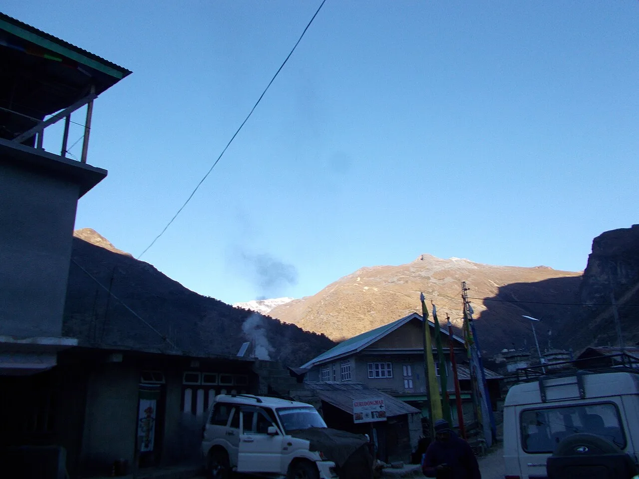
Thangu and Chopta Valley
Thangu and Chopta Valley is a town in Sikkim’s Mangan district, India, with an estimated population of 1,000. It is also known as Thangu Valley or Thangu-Chopta Valley.
Key facts · verified by Ghumoopedia editors
- Type of place
- Natural attraction
- Best time to visit
- March to May and October to December; avoid the June–September monsoon
- Nearest railway station
- Siliguri Junction · about 132 km (straight line)
- Nearest airport
- Pakyong Airport (limited, weather-dependent flights) · about 74 km (straight line)
- Verified
- 21 Nov 2026
Plan a trip from Thangu and Chopta Valley — a day-by-day route through places nearby.
Thangu and Chopta Valley is described as a town in Mangan district, in the Indian state of Sikkim. This places the settlement within that district and state. The place is also named Thangu Valley, while Thangu-Chopta Valley is another form used for it. These names offer alternative ways to identify the town. The population estimate for the place is around 1,000 residents. The figure is approximate, rather than an exact count. Sikkim is a small Himalayan state wrapped around Kangchenjunga, the world's third-highest peak, with Buddhist monasteries such as Rumtek, Pemayangtse and Tashiding, Lepcha, Bhutia and Nepali communities, high-altitude lakes like Tsomgo and Gurudongmar, rhododendron valleys at Yumthang and Varsey, and a strong commitment to organic farming and clean, plastic-light tourism. Weather depends on altitude: Gangtok and Pelling are mild in spring and autumn and cold in winter, while North Sikkim and Nathu La lie under snow from December to March. The monsoon (June to September) brings heavy rain and frequent landslides. Spring is rhododendron season; October and November give the clearest views of Kangchenjunga. The usual best time to visit is March to May and October to December; avoid the June–September monsoon. Timings, fees and access arrangements must be confirmed locally. For official information, see Sikkim Tourism at https://www.sikkimtourism.gov.in.
Why it matters
Thangu and Chopta Valley are high-altitude destinations in Mangan district, in North Sikkim. Their importance is primarily regional: the valley landscape and mountain setting form part of the journey north from Lachen towards places such as Gurudongmar Lake. Published accounts describe Thangu as a town and gives an estimated population of about 1,000; this should be treated as an estimate, not a current census figure. The area is also significant as a lived-in mountain region, rather than simply a viewpoint, so visitors should respect local homes, grazing areas and travel rules. Access is regulated, and current requirements should be checked before travel.
Thangu is a settlement in North Sikkim, in what is now Mangan district. The settlement’s identity is closely connected with the high mountain environment and the road corridor linking Lachen with more remote northern areas. In recent decades, this route has brought visitors travelling towards high-altitude lakes and valleys, alongside local movement and administrative or other permitted travel. Road conditions, weather and access controls have shaped how people reach the area; these arrangements can change, and the valley is not an unrestricted roadside destination. Thangu is described as a town with an estimated population of around 1,000, though the figure is not presented as a verified current count. There is no known major restoration project or historic monument at the destination to report. For its past and present, it is more accurate to understand Thangu as a living mountain settlement and part of North Sikkim’s changing travel network than to attach an unsupported foundation story to it.
Origin stories & folklore
Across Sikkim, mountains, rivers and high-altitude waters may be regarded with spiritual respect, and Buddhist and local beliefs are part of the region’s living culture. Such beliefs vary between communities and should not be presented as a single story belonging to this valley. Visitors may hear local accounts from residents or guides; treat these as oral traditions, ask permission before recording them, and avoid repeating sacred or private knowledge without consent. The landscape’s striking appearance can inspire stories, but it is better not to invent a named legend or claim a particular sacred origin for the place.
Spend unhurried time at Thangu and Chopta Valley: walk the marked paths, use official viewpoints and ask locally whether a guide, entry ticket or forest permission is needed. Weather can change quickly, so carry a rain layer even on a clear morning. A comfortable itinerary is one main visit in the morning, a local meal at midday and a short nearby stop before an afternoon return. In the mountains, mornings are clearest; clouds often roll in by noon, so start early for views of Kangchenjunga. Use the district list on this site to find other places in Mangan, but check the route and its condition before combining stops. If a festival is on — such as Losar (Tibetan New Year), Saga Dawa, Pang Lhabsol, Losoong, Bumchu at Tashiding, Dasain and Tihar or the Gangtok winter carnival — roads and stays can be busy, and the experience can be unforgettable. Leave no litter: Sikkim restricts plastic and packaged water in many tourist areas, so carry a refillable bottle.
Suggested itineraries
Half day: From an authorized vehicle, take a short orientation stop in Thangu (about 30–45 minutes), walk a permitted path or use an approved viewpoint (about 1–2 hours), then return for a warm meal or drink if available (about 45 minutes). Full day: Travel from Lachen with an authorized operator; pause for valley and landscape views (about 1–2 hours total), take a gentle permitted walk (about 1–2 hours), allow time for a meal and weather breaks (about 1 hour), then return before conditions or visibility worsen. Gentler option: Stay close to the vehicle in Thangu, choose a level roadside viewpoint only where stopping is allowed, and keep the outing short with frequent rests.
Life in Thangu and the surrounding North Sikkim region reflects mountain conditions, local community traditions and connections with Buddhist Sikkim. Nepali, Bhutia and Lepcha languages and cultural practices are present across the state; the languages spoken by a particular household or guide may differ. Monasteries and religious observances are important in the wider region, though visitors should not assume that every local practice is public or that a ceremony is staged for tourists. Traditional clothing may be worn for daily life or special occasions, rather than as a costume. Ask before photographing people, homes or religious activity. At this altitude, hospitality and practical considerations such as weather, road access and supplies shape visits as much as sightseeing does.
Local communities
Thangu is a lived-in settlement, and people in the wider Mangan district include Bhutia, Lepcha and Nepali communities. This broad regional description does not identify every household or imply that all residents share one language, faith or livelihood. In North Sikkim, livelihoods may include public service, local trade, transport, tourism-related work and activities adapted to a short growing season and challenging terrain. Some residents support visitors as drivers, hosts or guides, while others may have no role in tourism. Use locally arranged services where appropriate, follow access instructions, and ask before entering private land or photographing residents. Treat community knowledge and customary practices with respect.
Festivals & events
Losar, the Tibetan New Year, and Losoong, a Sikkimese harvest-season festival, are observed in parts of Sikkim; Saga Dawa and other Buddhist observances are also important in the wider region. Their timing follows religious or local calendars, so the season can vary. These are not guaranteed to be public events in Thangu itself. Ask locally whether any observance is taking place and whether visitors are welcome. Festival travel can add pressure to roads, accommodation and services, particularly in a remote mountain area. Plan flexibly, do not treat rituals as performances, and follow hosts’ guidance about photography, access and appropriate behaviour.
Local food in Sikkim includes momos, thukpa and thenthuk noodle soups, phagshapa (pork with radish), gundruk and sinki fermented greens, sel roti, churpi (yak cheese), chhurpi soup, local tea from Temi and warm tongba millet brew in the hills. Ask what is fresh that day; many small eateries cook a limited daily menu. Most food is mild compared with the plains, with plenty of vegetarian options; local chilli pastes made from dalle khursani are extremely hot, so try a little first. Hot soups and butter tea help at altitude. Remote sites may have no restaurant at all. Carry water and snacks, eat a proper breakfast before long drives, and ask your accommodation for a packed lunch if you are heading out early. Try a home-cooked or local thali meal when you can — it is often the best food on the route. Choose busy, clean places, drink sealed or filtered water, and carry your packaging back with you.
Shopping & local experiences
There is no large shopping district at Thangu, and the range of goods may be limited. In larger settlements along the route, look for locally made woollen items, woven goods or small regional crafts where they are genuinely produced and sold by local makers. Availability varies, so avoid assuming that a particular craft is made in the valley. Buying a simple meal or hot drink from a local business can be a useful way to support the area when services are open. Carry essential supplies from a larger town, use a refillable bottle where safe refill water is available, and avoid single-use packaging and souvenirs made from wildlife or natural materials.
Thangu and Chopta Valley lie in a high Himalayan landscape of open valley terrain, steep surrounding slopes and weather that can shift quickly. The route rises through North Sikkim’s mountain environment, where streams, seasonal snow and exposed ground are part of the scenery. Vegetation is shaped by altitude and a short growing season; alpine plants and grasses may be visible in suitable areas, while richer forests and rhododendron habitats occur elsewhere in the region and at different elevations. The exact appearance changes with season and conditions. Birds and other mountain wildlife inhabit the wider landscape, but sightings are never assured. Keep to permitted paths, avoid disturbing animals or grazing areas, and take all litter back with you. Cold, wind, rain and reduced visibility can affect even a short outdoor stop.
March to May and October to December; avoid the June–September monsoon
The nearest principal railway station by straight-line distance is Siliguri Junction, roughly 132 km away. The nearest operating airport by straight-line distance is Pakyong Airport (limited, weather-dependent flights), roughly 74 km away. These figures are calculated from map coordinates — actual road distance is longer, and mountain roads mean even short distances can take hours. Most travellers arrive at Bagdogra Airport or New Jalpaiguri (NJP) railway station near Siliguri in West Bengal, about 4–5 hours' drive from Gangtok; Pakyong Airport near Gangtok has limited, weather-dependent flights. Shared jeeps and reserved taxis run from Siliguri to Gangtok, Namchi, Ravangla and Pelling. Thangu and Chopta Valley lies in a permit area: book a registered tour operator or taxi from Gangtok (or Mangan for the north) at least a day ahead so the Protected Area Permit can be processed, carry the original photo ID you applied with, and expect checkpost stops on the way. North Sikkim trips usually run as two- or three-day packages with an overnight in Lachung or Lachen. When comparing train, bus and flight, count the complete door-to-door time: a flight saves the most time only if the onward road transfer is short, while an overnight train can save a hotel night. For Sikkim, flying into Bagdogra saves the most time from distant cities, while a train to NJP is cheaper; either way the road journey up the Teesta valley takes most of a day, so do not plan sightseeing on arrival. Book your return before you leave, because seats fill quickly on weekends, festivals and holidays. Current train numbers, timings, return services and fares are not listed here; check IRCTC and NTES for trains and the airline's own schedule for flights. Indian travellers need no permit for Gangtok, Pelling, Namchi and Ravangla, but a Protected Area Permit — arranged through a registered Sikkim tour operator or taxi association with photo ID and passport photos — is mandatory for Tsomgo Lake, Nathu La, North Sikkim (Lachung, Lachen, Yumthang, Zero Point and Gurudongmar), Zuluk and the Dzongri–Goecha La trek. Foreign nationals need a free Restricted Area Permit, issued online or at the Rangpo and Melli checkposts, and cannot visit Nathu La; some areas allow foreigners only in groups. Nathu La is open on limited days each week and closes after snowfall, and landslides can shut any road at short notice.
Confirm onward and return timings on IRCTC / NTES, the state bus operator or your airline before travel. A dash means current timings or fares have not been verified.
Getting around
Most visitors reach Thangu as part of an arranged North Sikkim road trip, travelling from Gangtok through the mountain route towards Lachen. Confirm that the vehicle and driver are authorized for the route and check road conditions before departure. Do not rely on regular local buses or autos for onward travel; availability may be limited. Around the settlement, short explorations are generally on foot, subject to weather, permission and safe roadside conditions. Parking and vehicle stopping places can be limited, so follow the driver’s instructions and do not block the road.
Hours, tickets & permissions
This is an outdoor valley and settlement rather than a conventional attraction with a confirmed gate schedule. Thangu and the route towards Chopta Valley are in a regulated permit area; visitors should arrange travel through a registered operator or taxi and confirm current authorization requirements before setting out. Rules may differ by route, nationality or conditions and can change. Carry the identification and permits requested by the relevant authorities. Do not assume that a camera, drone or particular viewpoint is permitted. Confirm any entry requirements, operating arrangements and applicable fees with the managing authority or registered local operator before travel; no reliable current hours or fee schedule is stated here.
Facilities
Facilities in Thangu are limited compared with towns at lower elevations. Basic food or accommodation may be available locally or through an arranged tour, but options and supply can vary by season and road conditions; check before departure. Toilets, reliable drinking-water refill points, public parking, guides and mobile connectivity should not be assumed at every stop. Carry water, snacks, necessary medicines and warm layers from a larger town. ATMs and broader services are more likely to be found in larger settlements on the journey, not at the valley viewpoints. Ask the operator about current facilities and dispose of waste responsibly.
Accessibility
This is a remote high-altitude mountain destination, and access involves a long road journey over terrain that may be rough or affected by weather. Walking surfaces can be uneven, exposed or muddy, and there may be no formed, step-free route at viewpoints. Distances between safe stopping places and facilities can be considerable. Wheelchair and stroller access should not be assumed; there are no confirmed ramps or accessible toilets described here. Older visitors and anyone with limited mobility should discuss the route, altitude, vehicle stops and walking needs with a local operator in advance. Allow time to rest, avoid strenuous activity, and seek medical advice if altitude or cold may pose a health concern.
Indian travellers need no permit for Gangtok, Pelling, Namchi and Ravangla, but a Protected Area Permit — arranged through a registered Sikkim tour operator or taxi association with photo ID and passport photos — is mandatory for Tsomgo Lake, Nathu La, North Sikkim (Lachung, Lachen, Yumthang, Zero Point and Gurudongmar), Zuluk and the Dzongri–Goecha La trek. Foreign nationals need a free Restricted Area Permit, issued online or at the Rangpo and Melli checkposts, and cannot visit Nathu La; some areas allow foreigners only in groups. Nathu La is open on limited days each week and closes after snowfall, and landslides can shut any road at short notice. Carry a photo ID at all times and save the emergency number 112 and your accommodation's contact offline. Mountain roads are narrow and prone to landslides, especially from June to September; travel in daylight, use experienced local drivers, and keep a spare day in your plan for road closures. Stay on marked paths, keep away from cliff edges and fast water, and never approach wild animals.
Photography
Early morning often offers the best chance of clear mountain views; cloud and weather can change quickly, so conditions are not guaranteed. Photograph only from safe, permitted stopping places and do not step into the road or onto private land for a view. Ask permission before photographing residents, workers or homes, and be especially considerate around religious observances. Drone use may be restricted by permits, local rules or security considerations; do not fly one without explicit current authorization. Protect cameras from cold, rain and wind, and carry out all packaging and waste.
Choose a stay by the full journey to Thangu and Chopta Valley, not just the district name. Permit-area trips usually include basic lodges in Lachung, Lachen or Zuluk; rooms are simple, heating is limited and power cuts are common, so carry warm layers and a torch. Nights are cold for much of the year — check heating, hot water and extra blankets. Book in advance for weekends, festivals and the peak season (March to May and October to December; avoid the June–September monsoon). Confirm the exact location, meals included, check-in time and cancellation terms in writing. Avoid sending money to unverified contacts or touts at stations. Carry some cash, as card and digital payments can be unreliable in remote areas.
Lachen is the main nearby settlement commonly used as a base for journeys into this part of North Sikkim. Gurudongmar Lake is a prominent high-altitude destination on the wider northern route, but access is permit-controlled and should be confirmed locally; it is not a casual add-on in poor weather. Chungthang lies on the broader road network connecting North Sikkim routes. Mangan town is the district headquarters and may be relevant for services or onward travel. Yumthang Valley is another well-known North Sikkim destination reached by a different route via Lachung, so combining it with Thangu requires careful planning rather than assuming a nearby stop. Check road status and permits before linking destinations.
For couples, Thangu and Chopta Valley rewards a slow pace: arrive early for soft light and fewer crowds, share a local meal and keep the evening free. Sunrise over Kangchenjunga from Pelling or Tashi View Point, a stroll on MG Marg in the evening or a quiet homestay night in a village makes the trip memorable. Public displays of affection can be frowned upon in conservative communities and at religious sites, so be discreet. Keep a buffer in your itinerary, because weather and road conditions can delay plans.
Q: How much time should I allow for Thangu and Chopta Valley? A: Allow at least a half day for a short visit, but many travellers include the area in a longer North Sikkim itinerary because road travel and weather can take time. Q: When is the best season to visit? A: March to May and October to December are commonly suggested for travel in Sikkim, but conditions at this altitude vary; check current weather and road reports. Q: Do I need permission to visit? A: The area is permit-controlled. Arrange travel through a registered operator or taxi and confirm current requirements with the relevant authority before departure. Q: Is the visit suitable for children or elderly visitors? A: It may be challenging because of altitude, cold, road conditions and uneven walking surfaces. Keep activity gentle and seek medical advice if concerned. Q: Where can I stay nearby? A: Lachen is a commonly used base for North Sikkim journeys. Accommodation in Thangu may be limited, so confirm availability and the route with an authorized local operator.
Be the first to share photos, stories, advice or a helpful contact for Thangu and Chopta Valley.
Loading…