
District · Chhattisgarh
Dhamtari
South of Raipur, Dhamtari offers a quieter view of central Chhattisgarh, where rice-growing plains, forested uplands and river landscapes meet.
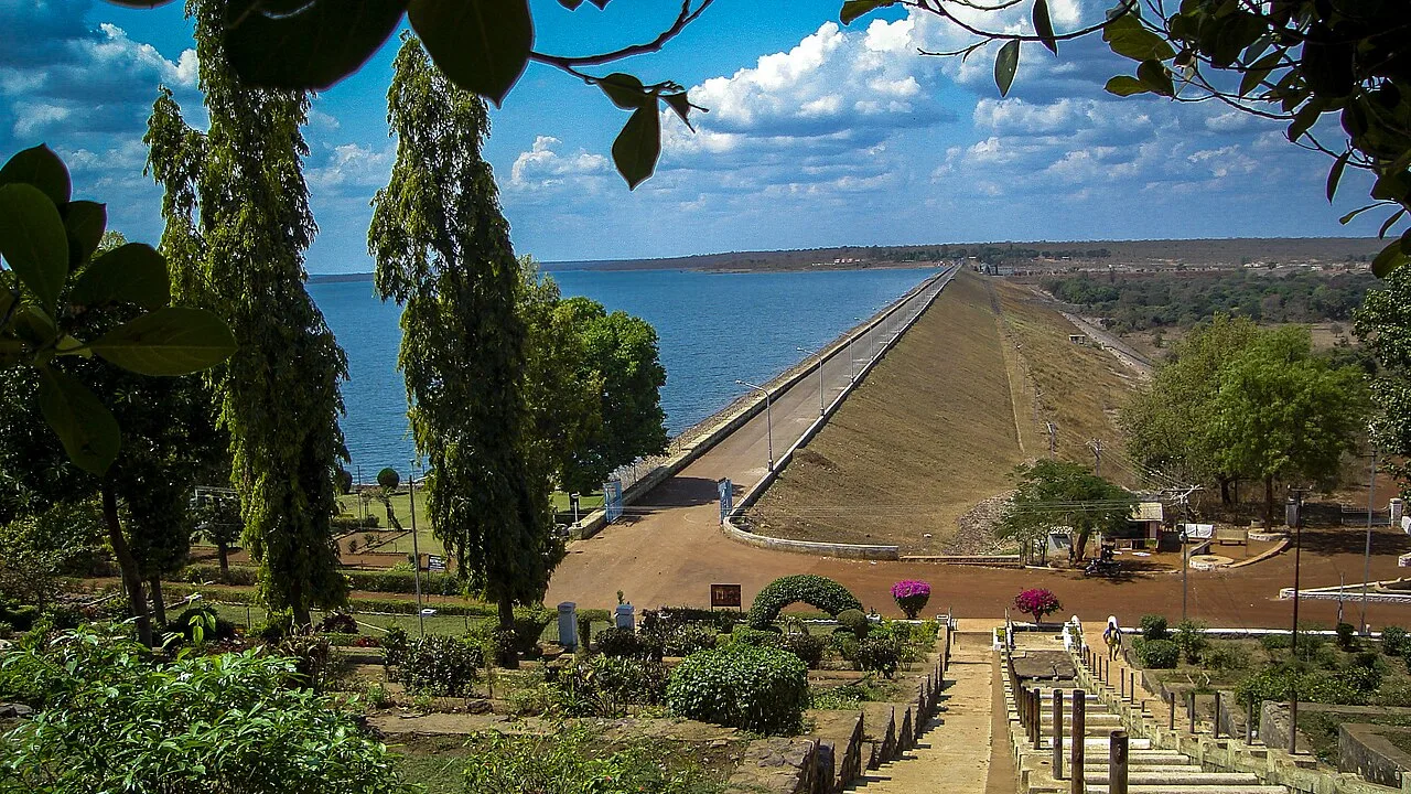
Dhamtari district lies south of Raipur, where cultivated plains meet forested hills in central Chhattisgarh. Rice fields, village settlements and the waters of the Mahanadi shape much of its landscape. The Sihawa hills are associated with the river’s origin, while Gangrel Dam, officially Pandit Ravishankar Sagar, is a prominent reservoir and visitor destination. Its broad waters offer a contrast to the district’s wooded interiors and agricultural countryside. Formed from Raipur district in 1998, Dhamtari combines a busy market-town centre with rural communities whose lives remain closely connected to farming and forests. It suits travellers interested in reservoir scenery, river landscapes and a quieter introduction to Chhattisgarh beyond its larger cities.
South of Raipur, Dhamtari offers a quieter view of central Chhattisgarh, where rice-growing plains, forested uplands and river landscapes meet. The district is best known for Gangrel Dam, officially Pandit Ravishankar Sagar, whose broad reservoir provides a striking change of scene from the surrounding countryside. The Sihawa hills are traditionally associated with the source of the Mahanadi, a river central to the region’s geography and livelihoods. Dhamtari town is a useful base for exploring the area, while villages and wooded interiors reveal the close links between farming, forests and everyday life. It suits travellers seeking scenery and a slower-paced regional visit.
The Dhamtari region has long been part of the cultural and political landscape of central India. In early historical accounts, the wider area is associated with Dakshina Kosala, an important kingdom in what is now Chhattisgarh and adjoining regions. Over later centuries, authority in parts of the region shifted among local rulers and the Kalachuri powers based at Ratanpur. The Maratha Bhonsles of Nagpur extended their influence over Chhattisgarh in the eighteenth century, before the area came under British administration in the nineteenth century. Under colonial rule, the region formed part of the Central Provinces and Berar. After Indian independence, it remained within Madhya Pradesh until Chhattisgarh became a separate state in 2000. Dhamtari district was carved out of Raipur district in 1998. Its history is also shaped by the Mahanadi basin, agricultural settlements and forest communities, though local histories and traditions vary from village to village.
Rice is central to food traditions across Chhattisgarh, including Dhamtari. Look for fara, steamed rice dumplings, and chila, a pancake commonly made with rice or lentils. Other regional preparations include muthiya, bafauri and aamat, alongside thethari and khurmi snacks. Pej, a simple grain-based preparation, reflects the region’s everyday rural food traditions. These dishes are part of a wider Chhattisgarhi repertoire rather than specialities exclusive to Dhamtari. Small eateries may serve only a limited daily menu, so ask what is freshly prepared. Vegetarian meals are generally easy to find in towns; carry drinking water and snacks when visiting quieter reservoir shores or forest-side locations.
Dhamtari can be approached through the wider craft traditions of Chhattisgarh rather than a single signature district craft. Bamboo basketry and utilitarian earthenware belong to the region’s rural material culture, with objects made for storage, cooking and agricultural work. Chhattisgarh is also known for kosa silk weaving and Bastar’s bell-metal casting, wrought-iron work and woodcarving, but these should not automatically be described as Dhamtari-made. When browsing markets or craft outlets, ask where an item was produced and whether it comes directly from an artisan. Locally made everyday objects can be as revealing as decorative souvenirs.
Hareli, usually observed during the monsoon, celebrates agriculture and the farming cycle in Chhattisgarh. Pola, around the harvest season, honours working cattle, while Teeja is widely observed by women and families. Navakhai marks the eating of new rice in parts of the region. Madai fairs are associated with tribal communities across Chhattisgarh; their timing and scale vary by locality, so not every fair is held in Dhamtari town. Festival periods can bring busier markets and fuller local accommodation, especially where a major fair is taking place. Check locally for event details before planning around a specific celebration.
Elsewhere in Chhattisgarh
Dhamtari’s northern and central areas include cultivated plains and settled river country, while forested hills rise towards the south. The Mahanadi and its tributaries shape the district’s agricultural landscape; the Sihawa hills are traditionally linked with the river’s origin. Gangrel Dam creates a broad reservoir amid this varied terrain. Roads connect the main town and settled areas, but reaching rural or wooded sites may take longer and require locally arranged transport. In the monsoon, wet conditions can affect smaller roads, while the reservoir and surrounding countryside are especially green.
Dhamtari has hot summers, a rainy monsoon and generally cooler, drier winters. Summer days can be uncomfortable for extended outdoor travel, so plan activities for the cooler parts of the day and carry sun protection. Monsoon rain brings lush landscapes but may make rural roads slower or less reliable. The most comfortable period for many visitors is from October through February, when conditions are usually milder and the countryside remains attractive after the rains. Pack light clothing for warm weather, a rain layer during the monsoon, and a warmer layer for winter mornings and evenings. Carry drinking water and sun protection in every season.
Swami Vivekananda Airport at Raipur is the main air gateway for Dhamtari. Raipur Junction is a practical mainline railway gateway, with onward travel by road. Dhamtari lies on National Highway 30, linking it with Raipur to the north and Kanker towards the south. Buses and hired cars are useful for reaching the district, while auto-rickshaws and locally arranged vehicles serve shorter journeys. Gangrel Dam requires an onward road journey from Dhamtari town. For Sihawa or less-frequented rural sites, arrange transport with the return journey in mind, since availability can be limited. Check current services locally.
Dhamtari town is the main local transport hub, with road connections along National Highway 30 towards Raipur and Kanker. Local buses and shared vehicles serve some towns and villages, but services to less-frequented rural areas may be limited. Auto-rickshaws are useful for shorter trips in town; taxis or a hired car offer more flexibility for Gangrel Dam and Sihawa. Arrange a return journey in advance when travelling beyond the main settlements. Boating or other visitor activities at the reservoir may be available when operating, but services can vary, so confirm locally.
2 days: Gangrel Dam; sleep in Dhamtari town both nights. 3 days: Gangrel Dam; sleep in Dhamtari town each night, allowing an extra day for a relaxed visit to the reservoir and nearby countryside.
Dhamtari town is the most practical base for a short district visit, with the widest choice of ordinary hotels and guest accommodation. It works well for road trips to Gangrel Dam and for onward travel towards Raipur or Kanker. Visitors heading to rural areas should confirm accommodation and transport in advance; choices outside the main town may be limited and can include basic guesthouses or locally arranged homestays. Government lodges or dharamshalas may be available in some places, but availability and facilities vary. Do not assume that a rural stay can be arranged on arrival.
Use care on rural and forest roads, especially during monsoon rain, when surfaces may be slippery or travel slower. Avoid swimming in the reservoir or river unless a locally authorised area is clearly designated, and follow any on-site safety instructions around water. Keep a respectful distance from wildlife and do not enter forest areas after dark. Carry drinking water and basic medicines; medical services and mobile connectivity may be less dependable outside town. Crowds can increase around festivals and fairs. Check road conditions and local guidance before setting out. No special permit requirement is established here; confirm officially if your planned route enters a protected area.
- Balodabout 37 km
- Gariabandabout 50 km
- Janjgir-Champaabout 59 km
- Durgabout 64 km
- Raipurabout 65 km
- Rajnandgaonabout 104 km
- Mahasamundabout 115 km
- Balangir · Odishaabout 140 km
Straight-line distance between the centres of each district's destinations; road distance is longer.
Q: How many days should I spend in Dhamtari? A: Two days can cover Gangrel Dam at a relaxed pace; allow three if you want more time for the surrounding countryside. Q: When is the best time to visit? A: October through February is generally the most comfortable period. Monsoon brings greener scenery but can slow road travel. Q: Where is the best base? A: Dhamtari town is the most practical base for accommodation and onward road journeys. Q: How do I get to Dhamtari? A: Travel via Raipur, the main air and rail gateway, then continue by road to Dhamtari. Q: Is Dhamtari suitable for families or elderly travellers? A: Yes, particularly for a town-and-reservoir visit, though arrange private transport for comfort and check walking surfaces and facilities at each stop.
This page draws on our 1 destination guides for Dhamtari and is updated as our team checks it.
Be the first to share photos, stories, advice or a helpful contact for Dhamtari.
Loading…