
District · Kerala
Malappuram
Malappuram sits in northern Kerala, between the Arabian Sea and the forested uplands of the Western Ghats.
Malappuram district stretches from the Arabian Sea coast and river estuaries through fertile midlands to the forested eastern hills. The Chaliyar and Bharathapuzha rivers shape its landscapes, while Nilambur is known for its teak forests. The district was formed in 1969 and includes places with deep historical associations, including Tirunavaya, remembered for the Mamankam festival, and Ponnani, an old port and centre of Islamic learning. Malappuram is part of the historic Malabar region and has a strong Mappila cultural presence alongside Kerala’s wider traditions. Its towns, rural settlements, river valleys and wooded uplands make it a varied district to explore.
Malappuram sits in northern Kerala, between the Arabian Sea and the forested uplands of the Western Ghats. It offers a mix of cultural history, wooded landscapes and coastal wetlands rather than a single-style itinerary. Travellers come for the Nilambur teak forests, the hilltop setting of Kottakkunnu and the historic river town of Tirunavaya, associated with the Mamankam festival. Kadalundi Bird Sanctuary, whose area spans Malappuram and Kozhikode districts, adds a place to observe wetland birds and estuary scenery. The district is also known for its strong Mappila Muslim cultural traditions and for towns that connect the coast with Kerala’s interior.
The Malappuram region has long been shaped by its position between the coast and the interior, with river routes, market towns and local chieftaincies linking it to wider Malabar. Tirunavaya is associated with Mamankam, a major medieval-era gathering held periodically on the Bharathappuzha riverbank under the patronage of the Zamorin of Calicut. The area also included territories connected with powers such as Valluvanad and the Zamorin’s kingdom. Portuguese and other European maritime interests affected the Malabar coast from the sixteenth century onward. In the eighteenth century, Mysore’s campaigns brought major political change; after the Mysore wars, the region came under British rule and formed part of Malabar district in the Madras Presidency. Malabar became part of Kerala when the state was formed in 1956. Malappuram district was established in 1969 from areas previously belonging to Kozhikode and Palakkad districts. Its history also includes the Mappila uprisings, particularly the 1921 rebellion, a complex episode rooted in colonial rule and agrarian and political tensions.
4 destination guides
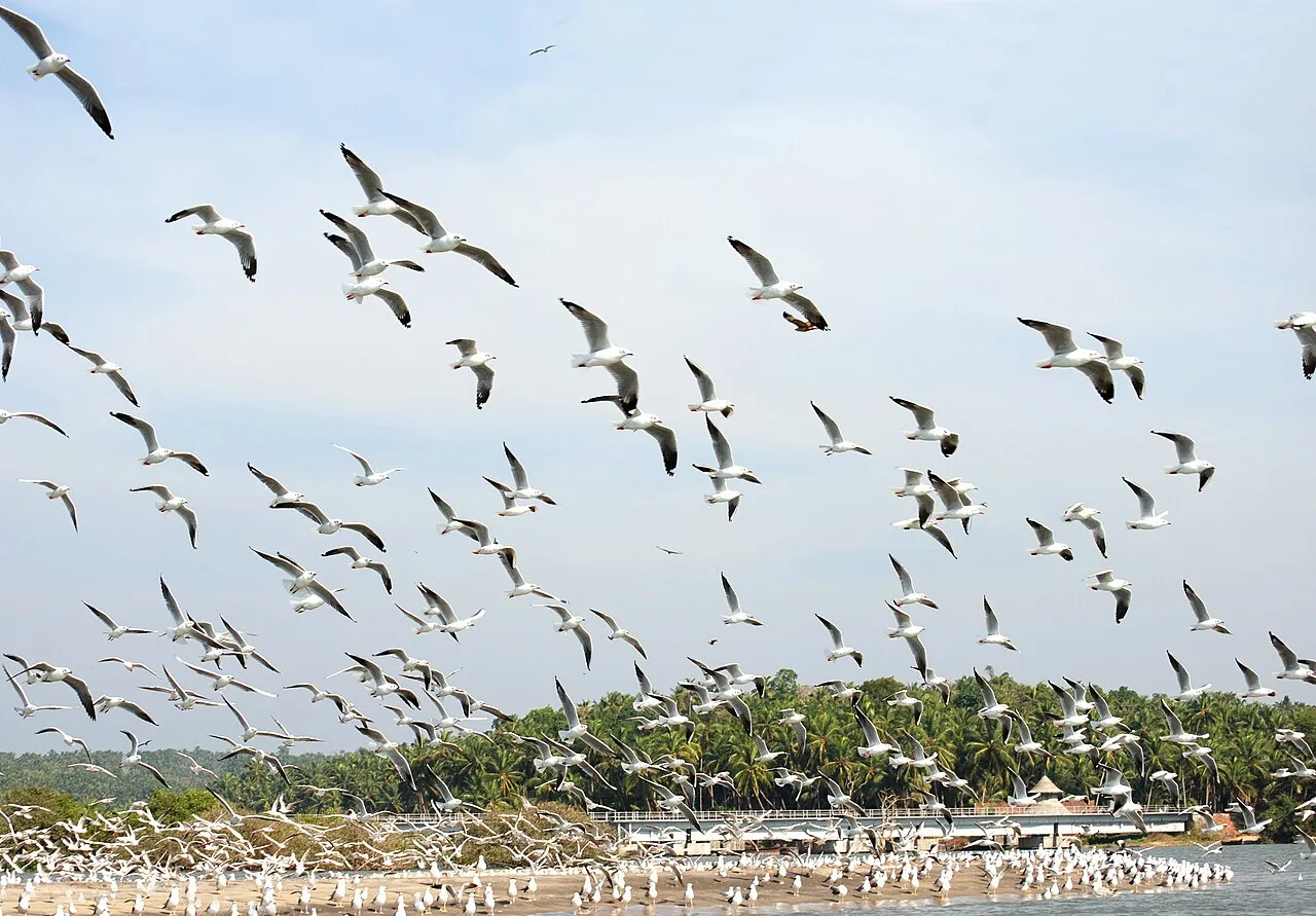
Kadalundi Bird Sanctuary
Kadalundi Bird Sanctuary is a Kerala nature reserve spanning parts of Kozhikode and Malappuram districts. Visitors come to watch birds in its island setting, where river and sea meet.
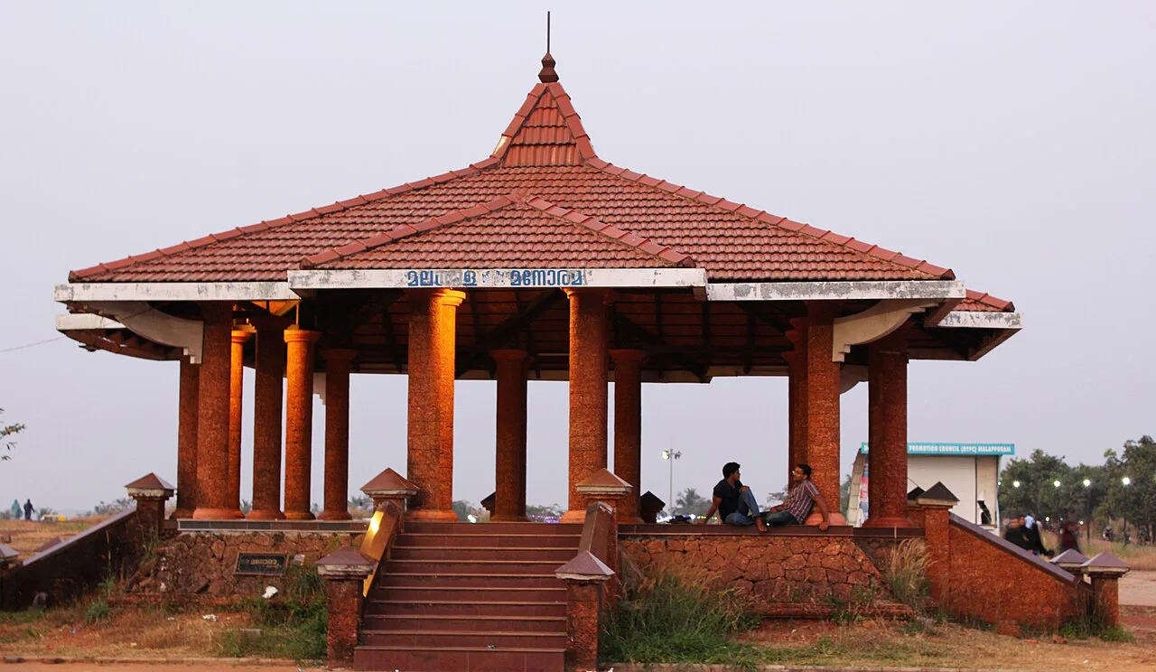
Kottakkunnu
Kottakkunnu, also called Kotta Kunnu, is a hill station in Kerala’s Malappuram district, rising to 120 metres. Visitors come to this popular tourist destination.
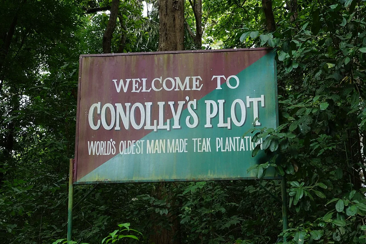
Nilambur Teak Forests
Nilambur Teak Forests are part of a wooded region in Malappuram district, Kerala, known for its teak, varied habitats and Chaliyar River setting. Visitors come to experience its forests and natural scenery.
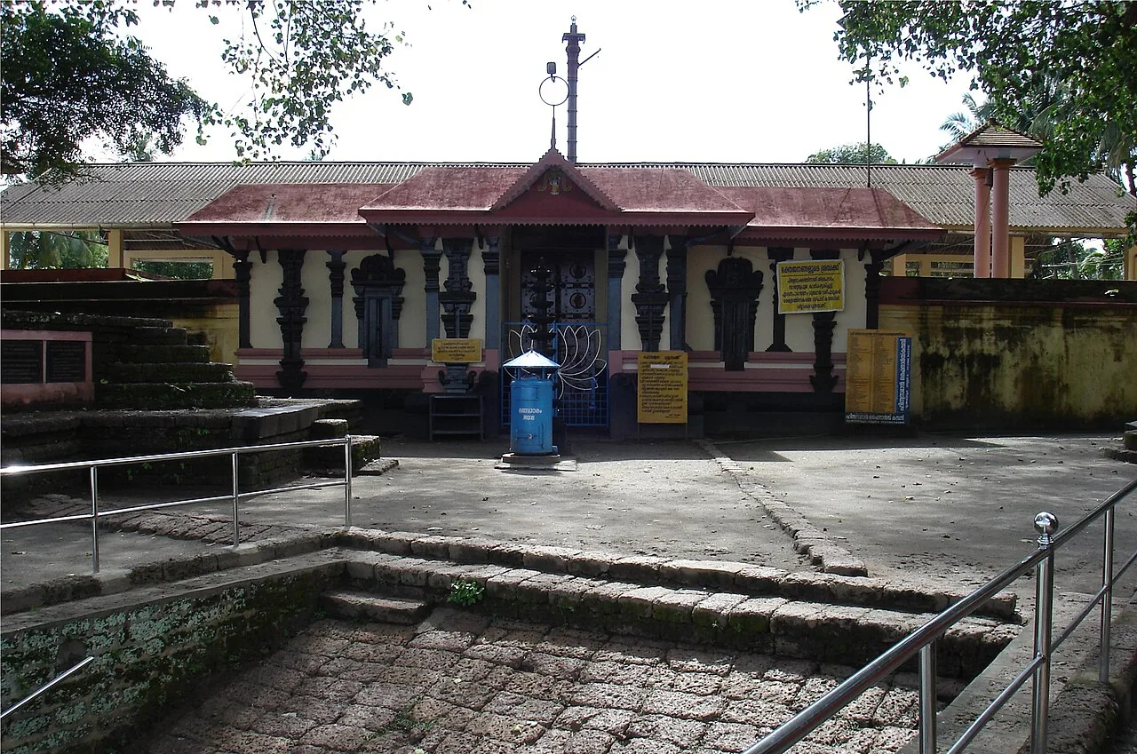
Tirunavaya
Tirunavaya, also called Thirunavaya, is a town in Kerala’s Malappuram district. Visitors come for its Hindu temples and bali tarpana observances on Karkitaka vavu.
Food in Malappuram reflects the wider Malabar region and Kerala’s use of rice, coconut and spices. Malabar biryani and pathiri are well-known regional dishes; appam with stew, puttu with kadala curry and idiyappam are also common across Kerala. Meals may include a banana-leaf sadya, while seafood is found in coastal areas. Banana chips and payasam are familiar snacks and sweets. Small eateries may prepare a limited menu each day, so ask what is fresh. Coconut and spice levels vary by dish; request less spice if preferred.
Malappuram’s cultural arts include Mappilappattu, a musical tradition of the Mappila community, as well as performance forms such as oppana, kolkali and daf muttu. These are living community traditions rather than crafts, and may be encountered at cultural events and celebrations. Handloom weaving and woodwork are part of Kerala’s broader craft heritage, though they are not exclusive to this district. In the Nilambur area, teak is a prominent part of local identity; this does not mean that every visitor will find a particular craft workshop or product there.
Onam is celebrated across the district in the late monsoon season, while Vishu falls in spring. Eid celebrations, including Eid al-Fitr after Ramadan and Eid al-Adha, are important across many local communities; the dates shift with the lunar calendar. Temple festivals and mosque nerchas take place at different times of year and can draw large local crowds. Tirunavaya is historically associated with Mamankam, though this is not a regularly recurring modern festival. During major festival periods, roads and public spaces can be busy, and accommodation in nearby towns may be more limited, so booking ahead is sensible.
Elsewhere in Kerala
Malappuram extends from a narrow stretch of coast and estuaries through cultivated plains and river valleys to the forested slopes of the Western Ghats. The Bharathappuzha flows by Tirunavaya, while the Kadalundi estuary and wetlands mark the district’s coastal edge. Inland, Nilambur is known for teak forests and wooded terrain. These varied landscapes make travel between destinations a mix of town roads, winding upland routes and coastal approaches. Rain can slow journeys, and access to forest or wetland areas may depend on local conditions and current site arrangements.
The district has a tropical monsoon climate. Summer, roughly from March to May, is generally warm and humid. The southwest monsoon usually brings frequent rain from around June into September, with further showers possible later in the year. Winter, broadly from December to February, is usually the more comfortable season for sightseeing, though humidity and rain can still vary. November to February is generally a good period to visit, especially for outdoor stops and birdwatching. Pack light clothing, sun protection and comfortable walking shoes; carry a rain jacket or umbrella during the monsoon and check local conditions before travelling to forests or wetlands.
Calicut International Airport at Karipur is the principal airport for Malappuram district. Tirur is a useful railway station on the coastal line, while Nilambur Road serves the eastern part of the district; the best station depends on your destination. National highways and state roads connect district towns with Kozhikode, Palakkad and other parts of Kerala. Buses, taxis and autorickshaws are common options for onward travel, though services can be less frequent in rural and forested areas. Plan local transfers around your itinerary and check current services locally before travelling.
Road travel is the practical way to link Malappuram town, Tirur, Tirunavaya and Nilambur. State and private buses connect many towns and larger villages, while local buses, autos and shared jeeps can help with shorter legs where available. Taxis are useful for combining outlying sights or travelling to forest areas, though it is wise to agree on the plan in advance. Kadalundi Bird Sanctuary is approached through coastal roads and local settlements on the district boundary. Boat access is not a general substitute for road transport; check locally whether any visitor boat service is operating.
2 days: Kottakkunnu → Tirunavaya; sleep night 1 in Malappuram. 3 days: Kottakkunnu → Tirunavaya → Kadalundi Bird Sanctuary; sleep night 1 in Malappuram and night 2 in Tirur. 4 days: Kottakkunnu → Tirunavaya → Kadalundi Bird Sanctuary → Nilambur Teak Forests; sleep nights 1–3 in Malappuram, Tirur and Nilambur, respectively.
Malappuram town is a convenient base for Kottakkunnu, while Tirur or nearby towns suit a visit to Tirunavaya and the coastal wetlands. Nilambur is the practical base for exploring the teak forest area. Larger towns generally offer hotels and some homestays; government accommodation or religious rest houses may be available in certain places but can be limited. Check facilities and access arrangements directly before relying on smaller-town or forest-edge stays, particularly during festival periods.
Wear suitable shoes on uneven, wet paths, and take care on forest roads, which can be slippery in rain. In Nilambur, follow local forest guidance, keep a safe distance from wildlife and do not enter restricted areas. At Kadalundi, avoid disturbing birds or walking onto unstable wetland edges. Use safe drinking water and take normal precautions against insects and sun exposure. Monsoon rain can affect road conditions and visibility; allow flexibility for travel. Mobile coverage can be weaker in wooded areas. Check official or local notices for current access rules and any permits before visiting protected or managed areas.
- Kozhikodeabout 34 km
- Wayanadabout 62 km
- Thrissurabout 65 km
- Palakkadabout 77 km
- Nilgiris · Tamil Naduabout 87 km
- Mahe · Puducherryabout 87 km
- Chamarajanagar · Karnatakaabout 95 km
- Coimbatore · Tamil Naduabout 102 km
Straight-line distance between the centres of each district's destinations; road distance is longer.
Q: How many days should I spend in Malappuram? A: Two days can cover a short town-and-heritage visit; three or four days allow time for the coast and Nilambur. Q: When is the best time to visit? A: November to February is generally comfortable for sightseeing, while monsoon months bring heavier rain. Q: Where is the best base for a visit? A: Malappuram town suits Kottakkunnu, Tirur suits Tirunavaya and the coast, and Nilambur suits the teak forests. Q: How do I get to Malappuram? A: The district is reached by road and rail connections serving its towns; Kozhikode International Airport is a nearby air gateway. Continue by road to your chosen base. Q: Is Malappuram suitable for families or elderly travellers? A: Yes, with route choices matched to mobility. Town visits are generally easier, while forest paths and wetland edges may be uneven or slippery.
This page draws on our 4 destination guides for Malappuram and is updated as our team checks it.
Be the first to share photos, stories, advice or a helpful contact for Malappuram.
Loading…