
District · Bihar
Nawada
Nawada lies in southern Bihar, within the wider historical and cultural region of Magadh.
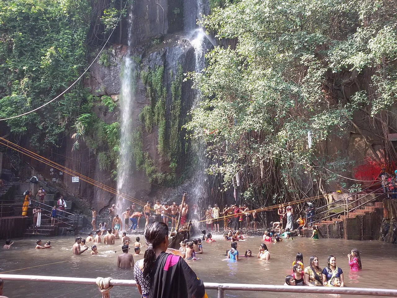
Nawada lies in southern Bihar, in the historic and cultural region of Magadh. Its landscape includes fertile plains as well as more rugged, undulating country toward the south, where low hills and wooded stretches approach the Jharkhand border. Kakolat Falls is among the district’s best-known natural attractions. The wider Magadh region has deep connections with ancient Indian history and the development of Buddhist and Jain traditions, though many major historic sites lie outside Nawada itself. Nawada district was separated from Gaya district in 1973. Today, the district combines busy market towns and rural settlements, with agriculture and local trade shaping much of everyday life.
Nawada lies in southern Bihar, within the wider historical and cultural region of Magadh. It offers a quieter way to explore this part of the state, with small-town life and a landscape that shifts from open plains to rocky, greener uplands. The district’s best-known published natural attraction is Kakolat Falls, where water drops over rock amid a wooded setting. Nawada is most rewarding for travellers interested in a short nature outing and a less urban view of Bihar, rather than a dense itinerary of documented monuments.
Nawada forms part of the wider Magadh region, whose political and religious history reaches back to ancient India. Magadh rose to prominence under early kingdoms and later became the centre of the Mauryan Empire, founded in the fourth century BCE. The broader region also saw the influence of later powers, including the Guptas and Palas, though that regional history should not be taken as evidence that every dynasty governed the present-day Nawada area directly. Over subsequent centuries, authority in Bihar shifted among regional kingdoms and larger states. Under British rule, the area was administered within the colonial province of Bihar and Orissa, established in 1912; Nawada was associated with the neighbouring Gaya district. Bihar became a separate province in 1936. Nawada district was formed in 1973, after being separated from Gaya district. Its history is therefore closely linked to the larger political story of southern Bihar, while the surviving record of specific local sites is more limited.
Nawada’s food reflects the wider Magadh and Bihar kitchen. Litti chokha and sattu paratha are filling local favourites; chana ghugni, thekua and malpua are also found across the region. Bihar sweets such as khaja, tilkut and anarsa are associated with places elsewhere in the state, but may be available in local markets. Many small eateries prepare a limited menu, so ask what is fresh that day. Vegetarian travellers have plenty of choices, and non-vegetarian dishes are also served in many towns. For trips to remote sites, carry water and snacks and eat before setting out.
Nawada is not widely identified with one signature craft, so visitors should treat craft availability as local and variable. In Bihar more broadly, pottery, handloom weaving, bamboo and cane work, and embroidery are part of varied craft traditions. Some celebrated forms, including Madhubani painting and Sikki grass work, are especially associated with other parts of the state rather than Nawada. Local markets may offer useful handmade household goods, but dedicated craft shops or workshops are not guaranteed; ask locally about makers and products before making a special detour.
Chhath, an important festival across Bihar, is observed in the autumn and again in spring, with worship and gatherings near water. Holi is celebrated in spring, while Durga Puja and Diwali bring community events in autumn. Makar Sankranti is observed in winter. These are regional traditions rather than events unique to Nawada. Towns can be busier around major festivals, and accommodation may be more in demand, especially where family visits and local gatherings coincide. Kakolat may also draw extra visitors during popular holiday periods; check locally before planning around a fair or event.
Elsewhere in Bihar
Nawada’s landscape includes settled plains and cultivated countryside, rising toward rockier, wooded uplands in the south. Seasonal streams and river channels cross the district, while Kakolat Falls is set among rocky terrain and vegetation. The contrast between flatter stretches and hill approaches makes road travel the practical way to reach sights, with journeys slowing on narrower or uneven roads. Monsoon water can make slopes and paths slippery, and the flow of streams and the appearance of the falls change with the season. This is an inland landscape, without a coastline.
Nawada has hot summers, a monsoon season and generally cooler winters. Summer days can make outdoor visits tiring, so plan time at Kakolat for cooler parts of the day and carry sun protection. The monsoon brings greener surroundings and stronger water flow, but rain can disrupt road travel and make rocks and paths slippery. Winter is usually more comfortable for sightseeing and walking. October to March is generally a suitable period for a visit, while conditions can vary from year to year. Pack light, breathable clothing for warm weather, a rain layer in the wet season, and sturdy footwear with grip for the waterfall area.
Nawada railway station serves the district headquarters, while Gaya Junction is another useful rail gateway. Gaya Airport is the nearest practical airport for many visits; Patna Airport offers another option. Road journeys connect Nawada with Gaya, Patna and neighbouring districts, and National Highway 20 is an important route through the area. Buses and shared vehicles serve town-to-town journeys, while hired cars or local autos can help with shorter trips. Reaching rural attractions such as Kakolat Falls may require arranging onward transport in advance. Check current services locally before travelling.
Nawada town is the main practical transport hub for exploring the district. Road connections link it with nearby towns and rural areas, while local buses, shared vehicles and autos may be available on commonly travelled routes; service can be less frequent in the countryside. Taxis or a hired vehicle offer more flexibility for reaching Kakolat Falls and returning the same day. The final approach may involve uneven roads or walking, depending on current access arrangements. Confirm local transport and road conditions before setting out, particularly during the monsoon. Do not assume a return vehicle will be readily available at the falls.
2 days: Nawada town → Kakolat Falls; sleep both nights in Nawada town. 3 days: Nawada town → Kakolat Falls → Kakolat Falls (a slower return visit); sleep both nights in Nawada town.
Nawada town is the most practical base for a visit centred on Kakolat Falls, with the broadest choice of ordinary hotels and guesthouses in the district. Smaller towns may have simpler rooms or lodges, but availability and standards can vary; confirm arrangements before travelling, especially during festival periods. Homestays and government lodges should not be assumed to be available without checking locally. A day visit from Nawada town is generally more straightforward than relying on accommodation near the falls.
At Kakolat Falls, rocks and steps can be slippery, especially after rain; stay on accessible paths, follow local instructions and avoid entering fast or deep water. Monsoon weather can affect road surfaces and access, so check conditions before travelling. Carry drinking water and use safe, treated water; bring essential medicines, as services may be limited away from town. Mobile connectivity can be uneven in rural and hilly areas, so arrange return transport in advance. Be respectful of local wildlife and do not approach or feed animals. No special permit requirement is confirmed here; check current rules with official local authorities before travel.
- Koderma · Jharkhandabout 43 km
- Nalandaabout 52 km
- Gayaabout 63 km
- Chatra · Jharkhandabout 65 km
- Jehanabadabout 66 km
- Hazaribagh · Jharkhandabout 73 km
- Giridih · Jharkhandabout 97 km
- Mungerabout 101 km
Straight-line distance between the centres of each district's destinations; road distance is longer.
Q: How many days should I spend in Nawada? A: One or two days can cover a visit focused on Kakolat Falls; allow more time if you want a slower pace. Q: When is the best time to visit? A: October to March is generally comfortable for sightseeing. Monsoon brings stronger water flow but can make access slippery. Q: Where is the best base? A: Nawada town is the most practical base for transport and a day visit to Kakolat Falls. Q: How do I get to Nawada? A: You can approach the district by road or rail through Nawada town, then arrange local road transport to your destination. Q: Is Nawada suitable for families or elderly travellers? A: It can suit families, but the waterfall approach may involve uneven, slippery terrain; assess mobility needs and avoid risky areas.
This page draws on our 1 destination guides for Nawada and is updated as our team checks it.
Be the first to share photos, stories, advice or a helpful contact for Nawada.
Loading…