
District · Rajasthan
Jhalawar
Jhalawar offers a view of south-eastern Rajasthan distinct from the state’s desert landscapes: river valleys, cultivated plains and low hills shape this part of Hadoti, near the Malwa plateau.
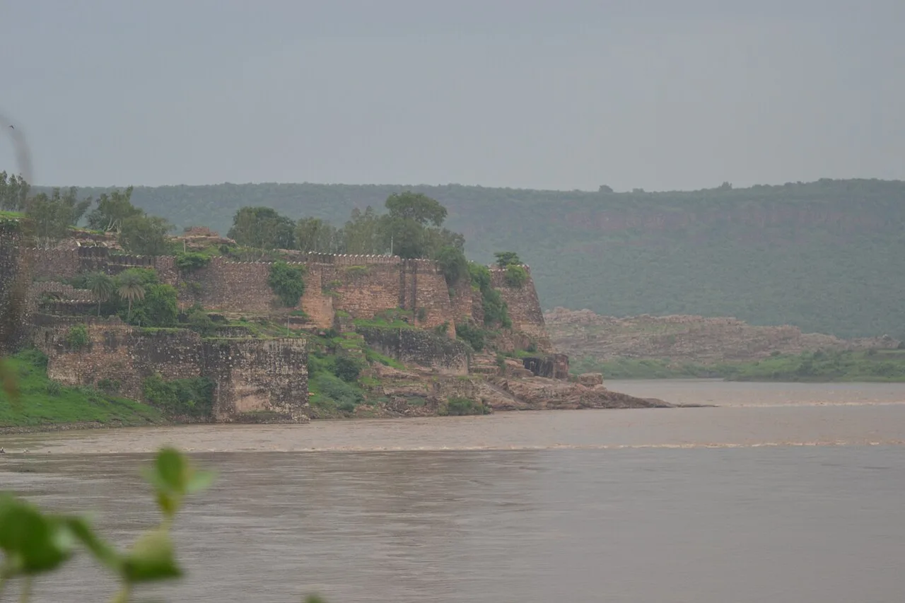
Jhalawar lies in Rajasthan’s south-eastern Hadoti region, where river valleys, cultivated plains and low hills create a greener landscape than the state’s desert image suggests. The district is known for citrus cultivation, particularly oranges, and its connections with the neighbouring Malwa plateau. Jhalawar town developed as the capital of a nineteenth-century princely state ruled by the Jhala dynasty. Its palaces and painted interiors reflect that courtly heritage. The district’s outstanding landmark is Gagron Fort, a hill and water fort protected by the meeting of the Ahu and Kali Sindh rivers. Part of UNESCO’s Hill Forts of Rajasthan listing, it anchors a district whose character combines agricultural countryside, fortified landscapes and Hadoti history.
Jhalawar offers a view of south-eastern Rajasthan distinct from the state’s desert landscapes: river valleys, cultivated plains and low hills shape this part of Hadoti, near the Malwa plateau. The district is known for citrus growing, especially oranges, and for the princely heritage of Jhalawar town, once the capital of a Jhala-ruled state. Its best-known landmark is Gagron Fort, dramatically set beside the meeting of the Ahu and Kali Sindh rivers and included in UNESCO’s Hill Forts of Rajasthan listing. Travellers can combine the fort with a quieter exploration of Hadoti history and agricultural countryside.
The Hadoti region has long been shaped by changing powers and its position between Rajasthan and the Malwa plateau. Gagron Fort was an important stronghold of the Khinchi Chauhans; it later passed through the hands of regional rulers, the sultans of Malwa and the Mughals, among others. In the early nineteenth century, Jhalawar emerged from the princely state of Kota. With British mediation, Madan Singh was recognised as ruler of a separate state in 1838, and the Jhala dynasty governed it under British paramountcy. Jhalawar town developed as the state’s capital, while nearby Jhalrapatan retained older religious and trading connections. The princely state continued through the colonial period, with changes to its territory and administration. After Indian independence, it joined the process of integration into Rajasthan. The modern district took shape as Rajasthan’s administrative boundaries were reorganised. Its heritage reflects both the local Rajput courts and the wider political shifts linking Hadoti, Malwa and central India.
Food in Jhalawar draws on the wider traditions of Hadoti and Rajasthan. Dal baati churma and gatte ki sabzi are familiar regional dishes, while kachori, spicy snacks and chaach make useful stops during a day of sightseeing. Ker sangri, laal maas and sweets such as ghewar belong to the broader Rajasthani repertoire rather than being specialities exclusive to this district; availability varies by eatery and season. Locally grown oranges are worth looking for during the harvest season. Small establishments may prepare only a limited daily menu, so ask what is fresh. Carry drinking water and snacks when visiting forts or rural sites away from town.
Jhalawar’s artistic heritage is particularly visible in palace painting and decorative interiors. The Garh Palace in Jhalawar is associated with murals that form part of the wider Hadoti tradition of courtly art. Nearby Kota and Bundi are better-known centres of miniature painting, offering useful regional context rather than crafts exclusive to Jhalawar. Kota Doria, the lightweight checked textile associated with the neighbouring Kota region, is another established Hadoti tradition. When shopping, ask where a piece was made and whether paintings are hand-painted or printed; locally sold souvenirs need not be locally produced.
The Chandrabhaga fair at Jhalrapatan, usually held around the Kartik season in autumn, is a prominent local pilgrimage and trading gathering. It can bring a noticeable increase in visitors, so rooms in the area may be harder to find during the fair. Gangaur, Teej, Diwali and Holi are also observed, as elsewhere in Rajasthan, with local processions or community celebrations varying by place. These festivals can make town centres busier and affect local transport; check conditions locally if travelling during a major celebration.
Elsewhere in Rajasthan
Jhalawar’s terrain includes cultivated plains, low hills and river valleys, with a greener appearance than Rajasthan’s arid western districts. The Ahu and Kali Sindh rivers meet beside Gagron Fort, giving the site its distinctive water-fort setting. Seasonal streams and rural roads connect settlements across the agricultural landscape, where citrus orchards are a familiar feature. The countryside is generally accessible by road, but reaching quieter sites may require a hired vehicle or locally arranged transport. Riverbanks and uneven ground call for care, especially during and just after the monsoon.
Summer is generally hot, and outdoor visits are more comfortable early or later in the day. The monsoon, usually spanning the middle part of the year, brings rain and greener scenery, but can make rural roads, slopes and river margins harder to navigate. Winter is comparatively mild and is usually the most comfortable season for sightseeing. October to March is a good broad window for a visit, with conditions varying from year to year. Pack sun protection and water in warmer months, and carry a light layer for winter evenings. During the rains, bring suitable footwear and check road conditions before setting out.
Jhalawar City railway station serves the district headquarters; Kota Junction is a major regional rail gateway, and Bhawani Mandi is another useful station within the district. Maharana Pratap Airport at Udaipur is an option for air arrivals, but the onward road journey is substantial. Compare flight access with rail connections before choosing your gateway. Roads connect Jhalawar with Kota and neighbouring Madhya Pradesh, with buses linking major towns. Auto-rickshaws suit shorter urban journeys, while hired taxis are useful for Gagron Fort and scattered rural attractions. Arrange return transport before visiting quieter sites, and check current services locally.
Roads connect Jhalawar town with Kota, neighbouring Madhya Pradesh and other district settlements. Buses serve major towns, though services to smaller rural places may be limited or less convenient for sightseeing. Auto-rickshaws are useful for shorter journeys within town. A hired taxi or locally arranged vehicle is practical for Gagron Fort and for combining stops outside the main urban areas. Confirm the return plan before visiting quieter sites, where onward transport may not be readily available. There is no need to plan a boat journey for the fort; check locally for current access conditions around the rivers.
2 days: Jhalawar town → Gagron Fort; sleep in Jhalawar town on night 1. 3 days: Jhalawar town → Gagron Fort; sleep in Jhalawar town on nights 1 and 2, leaving time for a slower countryside visit. 4 days: Jhalawar town → Gagron Fort; sleep in Jhalawar town on nights 1, 2 and 3, allowing a relaxed pace and flexibility for road conditions.
Jhalawar town is the most practical base for visiting Gagron Fort and arranging transport around the district. It suits short stays as well as a slower itinerary based in one place. Jhalrapatan may be convenient for visitors attending the Chandrabhaga fair or exploring the local area, though accommodation choices can be more limited. Stays in the district are generally town hotels and guesthouses, with some homestay or basic lodge options; availability varies by season. Dharamshalas may serve pilgrims, but facilities and access arrangements differ, so confirm suitability in advance.
Take care on uneven paths and steps at Gagron Fort, and keep away from river edges, especially during or after monsoon rain when water levels and surfaces can change. Carry drinking water, sun protection and any personal medicines; use reputable drinking-water sources. Rural roads may be narrow, rough or affected by rain, so allow flexibility and avoid relying on a late return from a quiet site. Mobile connectivity can vary outside towns. Wildlife encounters are possible in rural areas, so observe from a distance and do not feed animals. No special permit is generally expected for an ordinary visit, but confirm any current access rules with official local sources before travel.
Straight-line distance between the centres of each district's destinations; road distance is longer.
Q: How many days should I spend in Jhalawar? A: Two days can cover Jhalawar town and Gagron Fort at a comfortable pace. Add a day or two for a slower countryside visit. Q: When is the best time to visit? A: The cooler months from October to March are generally most comfortable for sightseeing. Monsoon brings greener scenery but can affect rural travel. Q: What is the best base for visiting the district? A: Jhalawar town is the most practical base for Gagron Fort and for arranging local transport. Q: How do I get to Jhalawar? A: Jhalawar City railway station serves the district headquarters; Kota Junction and Bhawani Mandi are other useful rail gateways. Roads and buses connect the district with nearby towns. Q: Is Jhalawar suitable for families or elderly travellers? A: Yes, with planning. Town-based stays and hired transport can make travel easier, but Gagron Fort has uneven terrain and may be challenging for visitors with limited mobility.
This page draws on our 1 destination guides for Jhalawar and is updated as our team checks it.
Be the first to share photos, stories, advice or a helpful contact for Jhalawar.
Loading…