
District · West Bengal
Purulia
On West Bengal’s western edge, Purulia is part of the Chota Nagpur Plateau region, where rocky uplands and red-earth valleys give the district a different character from the state’s delta and plains.
Purulia lies on West Bengal’s western edge, where the Chota Nagpur Plateau shapes a landscape of rocky hills, red earth, woodland and cultivated valleys. Ayodhya Hills is a major landscape attraction, while Joychandi Pahar offers another distinctive hill setting. At the foot of Panchet Hill, the ruined fort and surviving temple structures of Garh Panchkot recall the area’s former rulers. The district’s character also rests in its villages and the cultural traditions of its tribal and other rural communities, including Chhau dance. Rather than a single compact sightseeing centre, Purulia is a collection of hill landscapes, historic remains and village experiences; allowing time between stops makes for a more rewarding visit.
On West Bengal’s western edge, Purulia is part of the Chota Nagpur Plateau region, where rocky uplands and red-earth valleys give the district a different character from the state’s delta and plains. It is best known for the hill landscapes of Ayodhya Hills and Joychandi Pahar, the ruins of Garh Panchkot below Panchet Hill, and village traditions including Purulia Chhau. The sights are spread across the district rather than gathered in one centre, so the journey is as much about moving through rural landscapes as visiting individual landmarks. Purulia suits travellers who want a mix of hills, heritage and community culture, with time for unhurried road journeys.
Purulia’s past reflects its position between the Bengal plains and the plateau regions to the west. The wider Manbhum area had links with several neighbouring political and cultural centres over many centuries; local traditions and surviving remains also point to the presence of Jain communities in parts of the region. Garh Panchkot is associated with the Panchkot Raj, a local ruling house whose stronghold stood near Panchet Hill. Its fort and temple remains preserve traces of that history, though the ruins alone do not tell a complete account of the state’s former extent or chronology. Under British rule, the area was administered within Manbhum district. Changes to provincial boundaries placed Manbhum in Bihar and Orissa after the administrative reorganisation of 1912, and later in Bihar. A language movement in the region sought the inclusion of Bengali-speaking areas in West Bengal. In 1956, following the reorganisation of states and districts, Purulia district was formed in West Bengal from the transferred portion of Manbhum. Its present identity also draws on the distinct cultural traditions of its rural and tribal communities.
3 destination guides · 2 on the map
Ayodhya Hills
Ayodhya Hills is a hill or peak in Purulia district, West Bengal. Visitors come to experience a hill landscape in this part of the state.
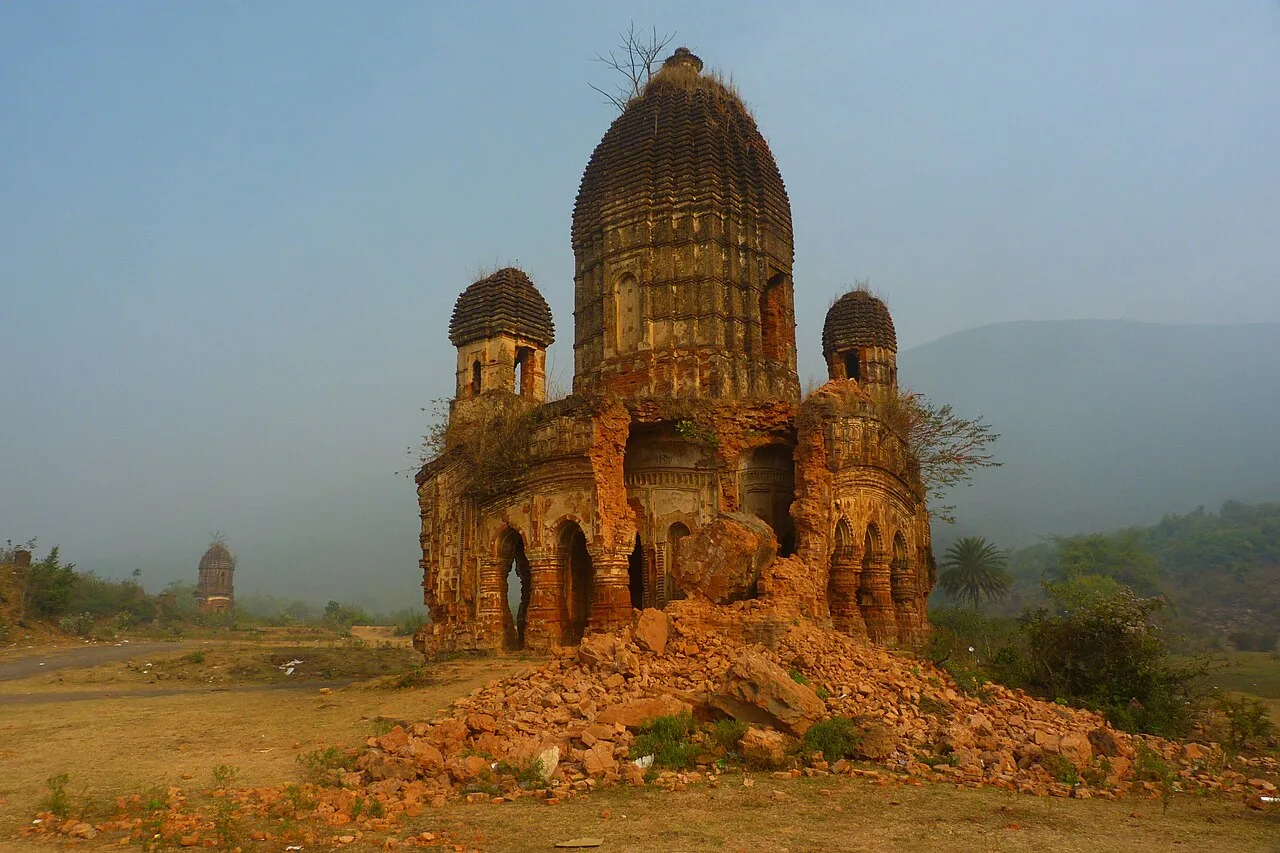
Garh Panchkot
Garh Panchkot is the remains of a fort in Purulia district, West Bengal. Visitors come to view the ruins at the foot of Panchet Hill and learn the meaning of its name.
Joychandi Pahar
Joychandi Pahar is a hill in Purulia district, West Bengal. Visitors come for its rock-climbing opportunities and to see the area's varied plant life and recorded butterfly species.
Food in Purulia draws on the everyday cooking of western Bengal, with rice, dal, seasonal vegetables and fish or meat where available. Familiar Bengali options include macher jhol, a light fish curry, and luchi with alur dom, though small rural eateries may serve only a simple daily meal. Pitha, a varied family of rice-based cakes and dumplings associated with seasonal celebrations, belongs to the wider region’s food traditions. Bengali sweets such as sandesh and rosogolla may be found in town sweet shops. Ask what has been freshly prepared, and arrange meals ahead when staying near remote hills or ruins.
Purulia is especially associated with the elaborate masks used in its Chhau dance tradition. Charida village, near Baghmundi, is a well-known centre of mask-making, where artisans build and decorate expressive faces and ornate headdresses using materials such as paper, clay, cloth and colourful embellishments. These masks are part of a living performance tradition, not simply souvenirs. Visitors can look for workshops selling directly and ask before photographing makers or their work. Terracotta and handloom textiles also belong to the wider craft heritage of West Bengal, but should not automatically be presented as Purulia-specific products.
Purulia Chhau, a masked dance tradition, is performed at cultural events and during seasonal celebrations; performances may draw visitors, so check local arrangements before travelling. Tusu Parab is observed around the winter harvest period and Makar Sankranti, while Bhadu is celebrated in the late monsoon season in parts of the region. Village fairs and local religious gatherings take place at different times of year, but their dates and scale vary by place. These events can make nearby rooms and transport busier than usual; book ahead when a major performance or fair is confirmed.
Elsewhere in West Bengal
Purulia’s plateau terrain includes rocky ridges, scattered hills, red-soil fields, woodland and cultivated valleys. Ayodhya Hills forms a prominent upland area, while Joychandi Pahar and Panchet Hill create distinct hill settings elsewhere in the district. Rivers and seasonal streams cross the landscape, with water levels and road conditions changing through the monsoon. Forested stretches and rural settlements lie between many sights, so journeys can take longer than a map suggests. The varied terrain makes road travel the practical way to explore, but visitors should allow time for winding routes and final approaches to hill sites.
Summer is generally hot, particularly in the drier months before the monsoon, so plan outdoor walks for cooler parts of the day and carry sun protection. The monsoon brings greener scenery but can also make rural roads muddy or uneven and complicate hill walks. Winter is usually the most comfortable season for visiting, with cooler mornings and evenings; the period from roughly October to February is a good general choice. Pack light, breathable clothing for warm days, a warmer layer for winter evenings, sturdy shoes, sun protection and rain gear if travelling during the wet season. Check local forecasts before setting out for the hills.
Purulia Junction is a useful rail gateway to the district, while Adra Junction serves its northeastern side. Asansol Junction can also be useful for approaching Garh Panchkot. Kazi Nazrul Islam Airport at Durgapur is an option for the northern attractions; Kolkata airport offers a broader choice of connections but requires a longer onward journey. Road routes connect Purulia with Kolkata, Asansol and neighbouring Jharkhand. Buses link major towns, while hired cars and locally available autos help with the final stretches. For scattered hill and heritage sites, arrange onward and return transport in advance. Check current services locally.
Purulia town is the main practical hub for road journeys, with routes connecting it to Raghunathpur, Baghmundi and other district towns. Local buses serve major routes, but they may not reach the final approach to a hill or heritage site. Autos and shared vehicles can be useful locally where available, though services may be limited or irregular outside town centres. For a circuit covering several scattered sights, a hired car with a driver is often the simplest option; agree on return arrangements in advance. There are no useful boat links between the listed destinations.
2 days: Joychandi Pahar → Garh Panchkot; sleep night 1 in Raghunathpur or near Panchet. 3 days: Joychandi Pahar → Garh Panchkot → Ayodhya Hills; sleep night 1 in Raghunathpur or near Panchet, night 2 in Baghmundi. 4 days: Joychandi Pahar → Garh Panchkot → Ayodhya Hills; sleep night 1 in Raghunathpur or near Panchet, night 2 in Purulia town, night 3 in Baghmundi.
Purulia town is the most flexible base for rail access, services and trips towards Ayodhya Hills. Raghunathpur or the Panchet area can suit visits to Joychandi Pahar and Garh Panchkot, while Baghmundi is useful for exploring Ayodhya Hills. Accommodation ranges from town hotels and guesthouses to homestays and smaller lodges near rural attractions; government or forest lodges may be available in some areas, subject to booking and current operation. Options can be limited outside the main towns, so arrange overnight stays before travelling between sites.
Hill paths and rocky ground can be slippery, especially during and after monsoon rain; wear secure footwear and avoid climbing in poor visibility. Heat, sun exposure and limited shade can make walks tiring, so carry drinking water and take breaks. Do not approach wildlife or walk alone through forested areas after dark. Rural roads may be narrow, uneven or affected by seasonal weather, and mobile connectivity can be patchy away from towns. Use safe drinking water and check road and weather conditions locally. Confirm any temporary access restrictions or permit requirements with local authorities before visiting; requirements can change.
- Dhanbad · Jharkhandabout 22 km
- Bokaro · Jharkhandabout 59 km
- Bankuraabout 67 km
- Giridih · Jharkhandabout 70 km
- East Singhbhum · Jharkhandabout 97 km
- Seraikela Kharsawan · Jharkhandabout 98 km
- Deoghar · Jharkhandabout 103 km
- Dumka · Jharkhandabout 103 km
Straight-line distance between the centres of each district's destinations; road distance is longer.
Q: How many days should I spend in Purulia? A: Two days can cover a couple of nearby sights; allow three or four days for a more relaxed trip including Ayodhya Hills. Q: When is the best time to visit? A: October to February is generally the most comfortable season, though local conditions vary. Q: What is the best base for visiting the district? A: Purulia town is a flexible hub; Baghmundi suits Ayodhya Hills, while Raghunathpur or the Panchet area suits Joychandi Pahar and Garh Panchkot. Q: How do I get to Purulia? A: Purulia Junction is a useful rail gateway. From there, use road transport to reach the district’s dispersed sights. Q: Is Purulia suitable for families or elderly travellers? A: Yes, with planning. Some hill approaches involve uneven ground, so choose accessible stops, allow extra travel time and check conditions before setting out.
This page draws on our 3 destination guides for Purulia and is updated as our team checks it.
Be the first to share photos, stories, advice or a helpful contact for Purulia.
Loading…