
District · Karnataka
Tumakuru
Tumakuru lies in south-central Karnataka, northwest of Bengaluru, and offers a quieter look at the state’s inland temple, hill and fort landscapes.
Tumakuru district lies in Karnataka’s southeastern interior, on the elevated Deccan plateau northwest of Bengaluru. Its landscape includes rocky hill ranges, cultivated plains and village tanks, with semi-arid conditions shaping much of rural life. Devarayanadurga is known for its hill setting and temples, while Madhugiri’s imposing rocky hill and fort are prominent landmarks. The district’s history is reflected in its forts, temples and older settlements, set within a region long connected to farming and trade. Tumakuru city is the main urban centre and a transport hub for surrounding towns. The district offers a quieter, varied landscape than the nearby Bengaluru metropolis, with hill visits and local town life both part of its character.
Tumakuru lies in south-central Karnataka, northwest of Bengaluru, and offers a quieter look at the state’s inland temple, hill and fort landscapes. The district is best known to visitors for the hilltop temples and wooded setting of Devarayanadurga and the steep rocky hill crowned by Madhugiri Fort. Its towns and villages are part of an agricultural region, with ragi and coconut among its familiar crops. Tumakuru suits travellers interested in short road trips, local religious sites and outdoor scenery rather than a dense circuit of large urban attractions. It can also be paired with a wider journey through the Bengaluru region.
The wider Tumakuru region has been shaped by successive South Indian powers, including the Gangas, Cholas, Hoysalas and the Vijayanagara Empire. Their influence is reflected in the area's temples, inscriptions and fortified settlements, though local sites have distinct histories. Madhugiri's hill fort developed under regional chiefs and later powers; its strategic position made the rocky hill important for defence. After Vijayanagara authority weakened, parts of the region came under local palegars and, in time, the rulers of Mysore. During the colonial period Tumakuru formed part of the princely state of Mysore, which was administered by the British for a period in the nineteenth century before princely rule was restored. After Indian independence, the state joined the Union as Mysore State. The present district belongs to the state renamed Karnataka in 1973. District administration and boundaries have changed over time, so the modern district should not be treated as a single historical kingdom.
2 destination guides
Devarayanadurga
Devarayanadurga is a hill settlement in Tumakuru district, Karnataka, where forested rocky slopes and hilltop shrines draw visitors. Its temples include Yoganarasimha and Bhoganarasimha.
Madhugiri Fort
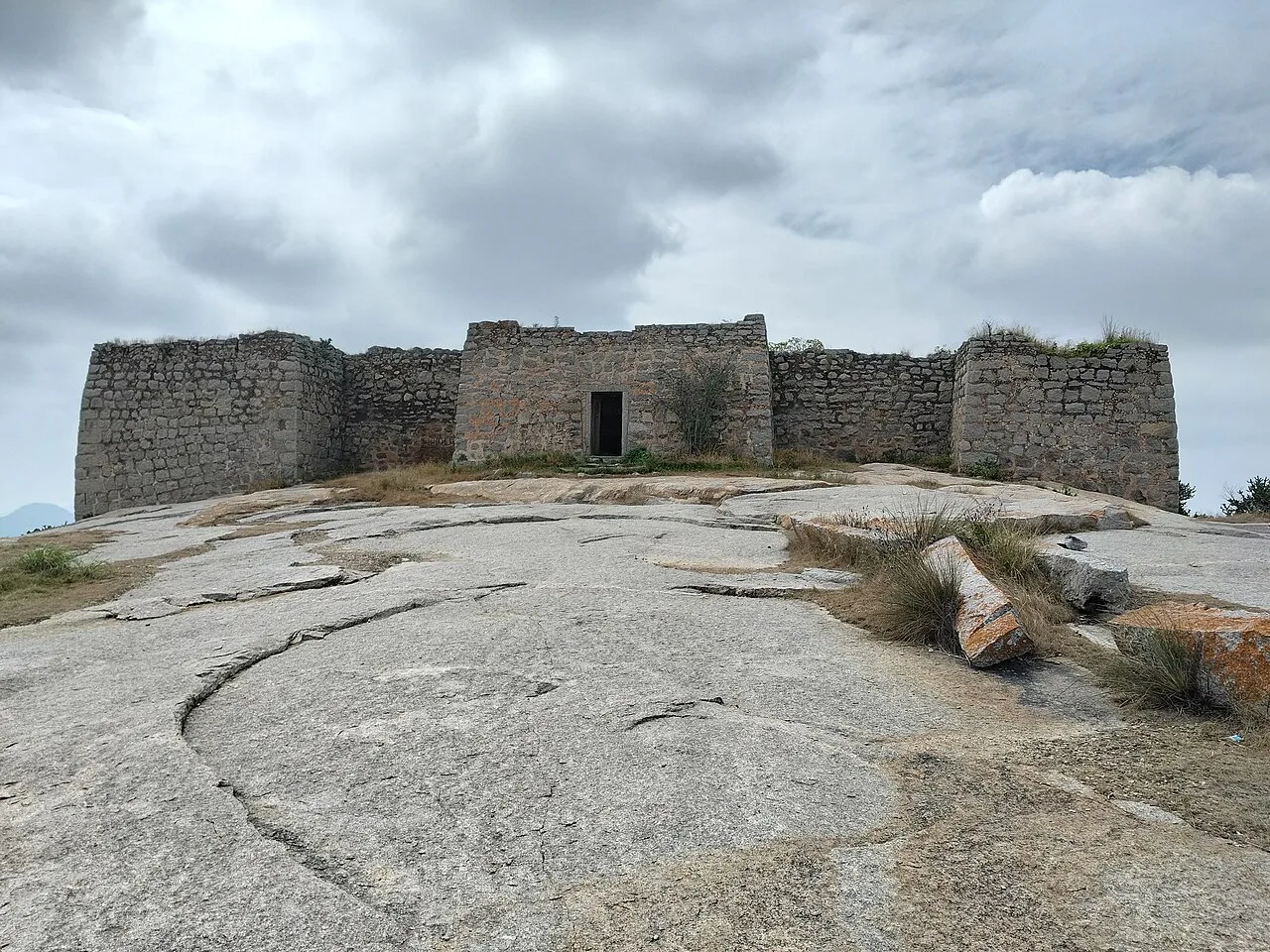
Madhugiri Fort lies in Tumakuru district, Karnataka. Visitors come to see the fort, while Madhugiri’s name reflects Madhu-giri, a hillock to the south.
Food in Tumakuru draws on the wider cuisine of southern Karnataka. Ragi mudde, often eaten with sambar or a vegetable curry, is a familiar regional staple, alongside rice-based meals, idli, vada and dosa. Bisi bele bath and masala dosa are widely available, as are simple vegetarian thalis and filter coffee. Small eateries may prepare a limited menu, so it is worth asking what is fresh that day. Menus and specialities vary between towns and rural areas; coastal seafood dishes and Coorg’s distinctive pork curry belong to other parts of Karnataka rather than being specific to Tumakuru.
Tumakuru does not have a single widely documented craft that defines the district. Everyday craft traditions found across Karnataka include pottery, metalwork, woodwork and handloom weaving, though what is made and sold locally can vary by town. The state is also known for traditions such as Mysore painting, sandalwood carving and Ilkal weaving; these are associated with broader or other parts of Karnataka and should not be mistaken for uniquely Tumakuru crafts. Visitors can look for locally made household goods and textiles in town markets, while asking sellers about their place of origin and production.
Ugadi, Deepavali, Dasara and Makara Sankranti are observed across the district, with customs and scale varying by town and community. Temple festivals and local jatre fairs are held at different times of year; celebrations around prominent shrines can draw visitors from nearby villages. Devarayanadurga and other religious centres may be busier during festival periods and auspicious seasons. Crowds and demand for rooms can rise locally during major events, although the effect is usually concentrated around the particular town or shrine rather than across the whole district. Check locally before planning a visit around a festival.
Tumakuru is an inland district of dry agricultural plains, rocky outcrops and isolated hills, with no coastline. Devarayanadurga rises above the surrounding countryside and has a hill-and-forest setting; Madhugiri is dominated by its steep, prominent granite hill. Seasonal streams and local reservoirs are part of the landscape, while the district lies within the wider east-flowing river systems of southern Karnataka. Towns and sights are spread across a broad area, so road journeys are central to exploring. Hill approaches may involve steep paths or steps, and monsoon weather can make exposed rock and trails slippery.
Tumakuru has a generally dry inland climate, with hot conditions before and during much of the summer, a southwest monsoon season, and milder, more comfortable weather in winter. The monsoon usually brings cloud, showers and greener hills, but can make rocky slopes and unpaved approaches slippery. November to February is generally the easiest period for sightseeing and outdoor walks. Summer outings are more comfortable early or late in the day; carry sun protection and drinking water. Pack light clothing for warm weather, a light layer for cooler winter mornings, and rain protection and shoes with good grip during the monsoon.
Tumakuru city is the district’s main rail gateway, while Kempegowda International Airport in Bengaluru is the principal air gateway for most visitors. Bengaluru connects to Tumakuru by the Bengaluru–Pune highway corridor, and roads link the district’s towns and hill destinations. For Devarayanadurga, Tumakuru is the nearest principal railway station; Madhugiri can be reached by road from Tumakuru and nearby towns. KSRTC and other buses serve regional routes, while taxis and auto-rickshaws can help with local journeys. Services to smaller destinations may be less frequent than those to major towns, so check current services locally.
Tumakuru city is a useful road and rail hub, and the main highway corridor links it with Bengaluru and other parts of Karnataka. State-run and private buses connect district towns, while local buses serve some routes; services to smaller sites may be less frequent. Devarayanadurga and Madhugiri are reached by road, with the final approach sometimes requiring a local auto, taxi or private vehicle. Shared jeeps may operate on some rural routes, but availability varies. Hiring a taxi or arranging a vehicle in advance offers more flexibility for visiting both destinations. There are no relevant boat connections for these circuits.
2 days: Devarayanadurga; sleep in Tumakuru; Madhugiri Fort; sleep in Tumakuru. 3 days: Madhugiri Fort; sleep in Tumakuru; Devarayanadurga; sleep in Tumakuru; keep the final day flexible in Tumakuru.
Tumakuru city is the most practical base for combining Devarayanadurga and Madhugiri Fort, with a broader choice of ordinary hotels and guesthouses than smaller towns. Madhugiri can suit a shorter visit to the fort, but room availability may be more limited, so confirm arrangements in advance. Around religious centres, basic lodgings or dharamshalas may sometimes be available, subject to local rules and availability. Homestays and government accommodation are not consistent across the district; check directly with the relevant operator or authority before relying on them.
Wear sturdy footwear on the steep, uneven approaches at Devarayanadurga and Madhugiri Fort; avoid exposed rock during rain and do not climb beyond marked or commonly used paths. Heat and sun can be tiring, so carry drinking water and take breaks. Roads outside towns may be narrow or uneven, and visibility can worsen in heavy rain or fog. Keep food and belongings secure around monkeys or other animals encountered near wooded or temple areas, and do not approach wildlife. Mobile coverage can vary in hill and rural areas. Ask site or forest authorities about current access conditions and any requirements before setting out.
- Chikkaballapurabout 55 km
- Bengaluru Urbanabout 73 km
- Ramanagaraabout 78 km
- Sri Sathya Sai · Andhra Pradeshabout 97 km
- Anantapur · Andhra Pradeshabout 114 km
- Chitradurgaabout 117 km
- Chittoor · Andhra Pradeshabout 129 km
- Kolarabout 129 km
Straight-line distance between the centres of each district's destinations; road distance is longer.
Q: How many days should I spend in Tumakuru district? A: Two days can cover Devarayanadurga and Madhugiri Fort; three days allow a more relaxed pace. Q: When is the best time to visit? A: November to February is generally comfortable for sightseeing; monsoon visits need care on slippery hills. Q: Where is the best base for these sights? A: Tumakuru city is the most practical base for both destinations and has a wider choice of stays. Q: How do I get to Tumakuru and travel around? A: Tumakuru is connected to Bengaluru and other cities by road and rail; use buses or arrange a vehicle for local sightseeing. Q: Are these visits suitable for families or elderly travellers? A: The towns and road journeys can suit families, but steep, uneven hill approaches may be difficult for people with limited mobility.
This page draws on our 2 destination guides for Tumakuru and is updated as our team checks it.
Be the first to share photos, stories, advice or a helpful contact for Tumakuru.
Loading…